Chapter: 14
Understanding the Urban Estuarine Ecology of the Mhadei: The Role of Khazans in Panjim, Goa
Leon Morenas and Manisha Rodrigues
Abstract
The Mhadei river, also known as the Mandovi, is central to Goa’s ecological and cultural identity, including the development of the capital city Panjim. Situated in a low-lying estuarine region, Panjim is particularly vulnerable to flooding, especially during the monsoons. Traditional khazan systems have historically regulated water flow and salinity, preserving both agricultural productivity and ecological balance. However, rapid urbanization—accelerated first in 1843 after Panjim became the Portuguese colonial capital and later post-Goa’s liberation in 1961, continuing to the present—has led to significant ecological degradation. Pollution, inadequate sewage management, and the decline of khazan systems have severely deteriorated water quality and compromised flood management. Global examples, such as the revitalization of the Thames in London and the Han River in Seoul, illustrate effective strategies for addressing these challenges. This study underscores the urgent need for sustainable urban planning and the revival of traditional systems to balance development with preserving the estuarine environment of the Mhadei.
1. Introduction
THE Mhadei river is also called the Mahadayi in Karnataka, which translates to the “great mother.” It is central to Goa’s ecological and cultural identity and has played a pivotal role in the capital Panjim’s development. Panjim, situated in a low-lying estuarine region, was reclaimed from marshlands within the floodplain. It is therefore particularly vulnerable to flooding, especially during the monsoons. Traditional khazan (constructed tidal wetlands) systems have historically regulated water, preserving both agricultural productivity and ecological balance, not only in Panjim but in many parts of Goa (Kamat 2004).
However, rapid urbanization—accelerated after Panjim became the Portuguese colonial capital in 1843 and after Goa’s liberation in 1961 and further intensified by the rise of tourism—has severely impacted the region’s ecological balance (Alvares 2002). The 2001 census revealed a population increase of almost 50 percent since the 1991 census in Panjim (City Population n.d.), prompting the transformation of low-lying lands into developed areas for real estate projects. Although the later 2011 census has an increase of only about 10 percent (City Population n.d.), construction, pollution, inadequate sewage management, and the decline of khazan systems and wetlands have severely compromised water quality and flood management. Additionally, infrastructure developments projects have contributed to land fragmentation, and the disruption of fragile marine ecosystems.
Panjim is often viewed as an economic hub for the state of Goa, playing a central role in generating economic activity (Sawkar et al. 1998). However, the methods and framework used to drive this economic growth often over-look the sensitivity of the region’s ecological system. This raises important concerns regarding the long-term sustainability of both the city’s development and its environment.
What are the problems with the current development approach? Can Panjim be treated like any other city in India in terms of its future development? What kind of development approach should Panjim adopt? The strategic location of Panjim within an ecologically sensitive zone, bounded by the river Mhadei to the north, demands a carefully planned approach to development. The city cannot be treated as just another urban area, given its unique environmental context.
2. Ecological and Cultural Significance of the Mhadei River and Wetlands System/Watershed
North Goa district can be geographically categorized into four distinct morphological zones, arranged from west to east as (i) a coastal plain with marine land forms on the west; (ii) a vast stretch of plains adjoining the coastal plain; (iii) low, dissected denudational hills and plateaus towards the east; and (iv) deeply dissected high Western Ghats denudational hills along the eastern most part of the district (Central Ground Water Board 2010).
The district is drained by several major perennial rivers, including the Terekhol, Chapora, Mhadei, and Zuari, along with other smaller rivers (Sawkar et al. 1998). These westward-flowing rivers originate in the Western Ghats and flow into the Arabian Sea under estuarine conditions, from which the Mhadei and the Zuari receive maximum freshwater runoff (up to ∼ 400 m3/s discharge) from June to September every year during the monsoon. Thereafter the flow becomes primarily tidal, until the start of the following monsoon season (Toraskar et al. 2022). The drainage system is largely influenced by the underlying rock formations and typically follows in a dendritic pattern (Central Ground Water Board 2010).
A dendritic drainage pattern resembles the branching structure of a tree where numerous small tributaries merge into larger streams, forming an efficient network for water flow. This pattern typically develops in regions with relatively uniform geological structures, allowing rivers to follow the natural slope of the terrain. As the largest river basin in Goa, the Mhadei is a key perennial waterway, significantly shaping the region’s hydrology. In the Mhadei river region, this dendritic system historically facilitated efficient stormwater flow, supporting wetlands and khazan systems.
The Mhadei River and its surrounding wetlands host a diverse ecosystem, rich in both flora and fauna, with mangroves, fish species, and aquatic plants forming a critical foundation. Mangroves not only protect the riverbanks from erosion but also serve as nurseries for various fish and crustacean species, essential to the region’s aquaculture and fishing industries (UNEP 2023). These wetlands sustain a wide variety of life, providing local communities with food and livelihoods, as generations have relied on the river’s resources (IUCN 2017).
The Mhadei’s cultural history is deeply intertwined with these communities, which have traditionally depended on it as a trade route and a vital source of sustenance (Das 2023). Traditional khazan systems—constructed tidal wetlands—have played a central role in sustainable agriculture, flood management, and salinity control (Jnana Foundation 2023). The knowledge of the construction, ecology and maintenance of the khazan system was passed down orally from one generation to the next without any written document (Sonak 2014). These engineered systems were constructed traditionally through indigenous ecological and technical knowledge and played an important role not only for the food needs of the communities dependent on it but also for the harmonious integration of natural systems with human activity fostering in the process, a unique cultural and economic relationship, anchoring both the livelihoods and heritage of the region. To this day many of our cultural as well as religious ceremonies are linked to the khazans (Jacob 2018). However, post-liberation, Goa’s focus shifted towards mining and tourism, often at the expense of environmental considerations (Trichur 2013; Alvares 2002).
3. Vulnerability of Panjim’s Estuarine Setting
With a tropicalclimate characteristic of coastal regions, the city sees high humidity throughout the year, with the monsoon season being particularly wet. During the monsoon, Panaji receives heavy rainfall, which significantly contributes to groundwater recharge in the region which in turn sustains the hydrological balance of the Mandovi River watershed. However, this same period also brings challenges, particularly in terms of drainage management.
Located at the confluence of the Mhadei and Zuari rivers, Panjim is a coastal city that frequently experiences flooding due to storms and severe rainfall and lately due to other human-induced factors. Its distinct hydrogeological features, including the coastal plain region, characterized by flat, low-lying areas are typical of the region. This makes it more susceptible to problems such as salinity intrusion and flooding during the monsoon season. The surrounding landscape comprises a mix of hilly terrain and plateau, which influences drainage and runoff patterns in and around the city.
As the city has grown, urbanization and land-use changes have increasingly disrupted this natural drainage network. These changes have compounded existing challenges, leading to more frequent flooding, reduced groundwater recharge, and heightened salinity intrusion in traditionally managed tidal wetlands (Kamat 2004). This shift underscores the tension between urban expansion and ecological sustainability.
Panaji spans an area of 8.19 square kilometres, with a resident population of approximately 165,000 and a floating population of more than 5,000 to 15,000 consisting of tourists as well as locals travelling to the capital city for jobs (ICLEI South Asia 2023). While the city boasts a grid-pattern layout with significant phases of colonial and post-liberation urbanization, its drainage system—both natural and man-made—has struggled to keep pace with the demands of expanding city (TNN 2022). There are two major creeks in Panjim, the Rua de Ourem, and the Santa Inez Canal—as well as more than sixty smaller creeks that once formed a robust drainage network, ensuring the seamless outflow of stormwater into the Mhadei river (Dinesh Ramanathan et al. 2021). Bounded to the east by Rua de Ourem Creek, to the north by the Mhadei river, to the southeast by Altinho Hill, and to the west by the Taleigao hamlet and the St. Inez Creek, this intricate system once played a crucial role in managing floodwaters. Increasing urbanization has, however, significantly altered its functionality.
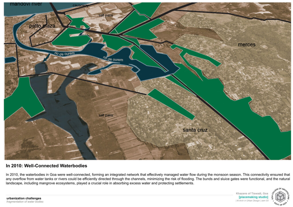
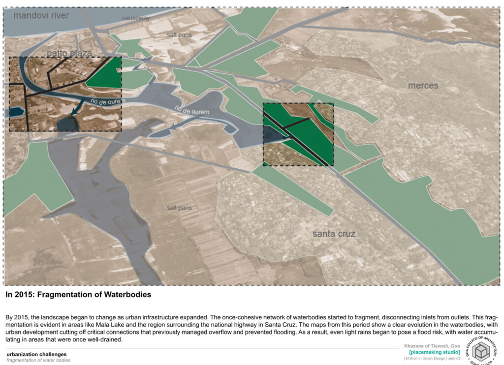
Fig. 14.1: Network of drainage through creeks. Source: Khazans of Goa: Documentation and Mapping, M. Arch, Second year, Goa College of Architecture, 2024.
As the city is mostly situated on reclaimed land in the floodplain of the Mhadei estuary (except for higher terrain areas like Altinho), the city’s low-lying ponds and marshes acted as a buffer against flooding, while mangroves and khazans protected the shoreline and embankments-controlled runoff (Goa College of Architecture Urban Design Studio 2024). The city’s elevation although mainly low lying varies from sea level to about 50 meters, with many of the areas just 2–4 meters above mean sea level (Dinesh Ramanathan et al. 2021).
The St. Inez creek originating near Camrabhat meanders for almost six kilometres along the western slopes of the Altinho Hill before emptying into the Mhadei River near the Inox Complex. As early as 1829, it was documented as the city’s primary drainage spine, functioning as a natural outlet for surface water while also playing an important environmental and cultural role (Dinesh Ramanathan et al. 2021). The Rua de Ourem Creek acts as a tidal estuary, primarily draining the Mala and Fontainhas areas before eventually merging with the Mhadei. Historically, both creeks were connected to an extensive network of wetlands and khazan lands, which regulated tidal flow, prevented saline intrusion, and supported traditional agriculture and aqua-culture.
Despite their importance, both creeks have suffered from urban encroachment. Once surrounded by wetlands and open spaces, their edges have become heavily built up, diminished in size and polluted altering their flow. This transformation has not only reduced their capacity to function as drainage channels but has also weakened their historical connection to the khazans, which relied on free-flowing estuarine waters for controlled irrigation and flood management.
Many of these creeks, which once drained directly in to the river, have now been fragmented and constricted as seen in Fig. 14.1. Their depth and width have significantly decreased due to garbage dumping and land reclamation. This in turn has led to increased flooding during the monsoon and a gradual loss of other ecological services that once sustained both the creeks and the khazan landscape.
The creeks of Panaji also form part of the city’s rich heritage. Built in the colonial era they form part of the history of the city and are still functioning to this day. Protecting such waterways is crucial, not only for managing flooding during the monsoons but also for preserving the city’s cultural identity. Unfortunately, urbanization has relegated these natural assets to the periphery of urban planning, with little regard for their environmental or heritage value.
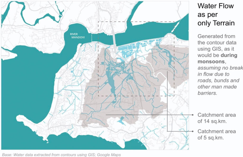
Figure 14.2 Water flow map. Source: Khazans of Goa: Documentation and Mapping, M. Arch, Second year, Goa College of Architecture, 2024.
Apart from this, open spaces like hills, paddy fields and wetlands are replaced by asphalt and concrete, leaving little space for water percolation in many areas. This, coupled with the progressive raising of road levels due to layers of tar over the years, has left many older buildings with plinths below street level, making them highly susceptible to monsoon flooding (Dinesh Ramanathan et al. 2021). As the city expanded, the network of drains may have been upgraded to handle increased stormwater, but done in a piece-meal manner, is unable to deal with this increased flooding in the city.
The drainage system now also faces significant operational challenges. Most drains are now covered with concrete slabs, which feature small openings for aeration and water percolation (Dinesh Ramanathan et al. 2021). These small inlets, however, are often clogged with debris, silt, and waste, including plastics and paper. As a result, stormwater runoff, which moves rapidly during intense rains, is unable to enter the drains efficiently, leading to waterlogging in many parts of the city.
The loss of wetlands in areas like Bhatlem, St. Inez, Campal, and Miramar further compounds the issue. Wetlands act as natural flood buffers, absorbing excess stormwater and reducing the risk of flooding. Their disappearance in many areas has not only diminished Panaji’s flood resilience but has also led to significant biodiversity loss and ecological balance. Encroachments along the St. Inez Creek highlight the tension between urban development and environmental sustainability (Dinesh Ramanathan et al. 2021).
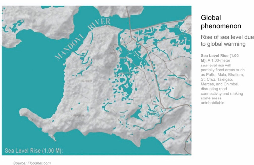
Figure 14.3: Rise in sea level of 1 metre. Source: Khazans of Goa: Documentation and Mapping, M. Arch, Second year, Goa College of Architecture, 2024
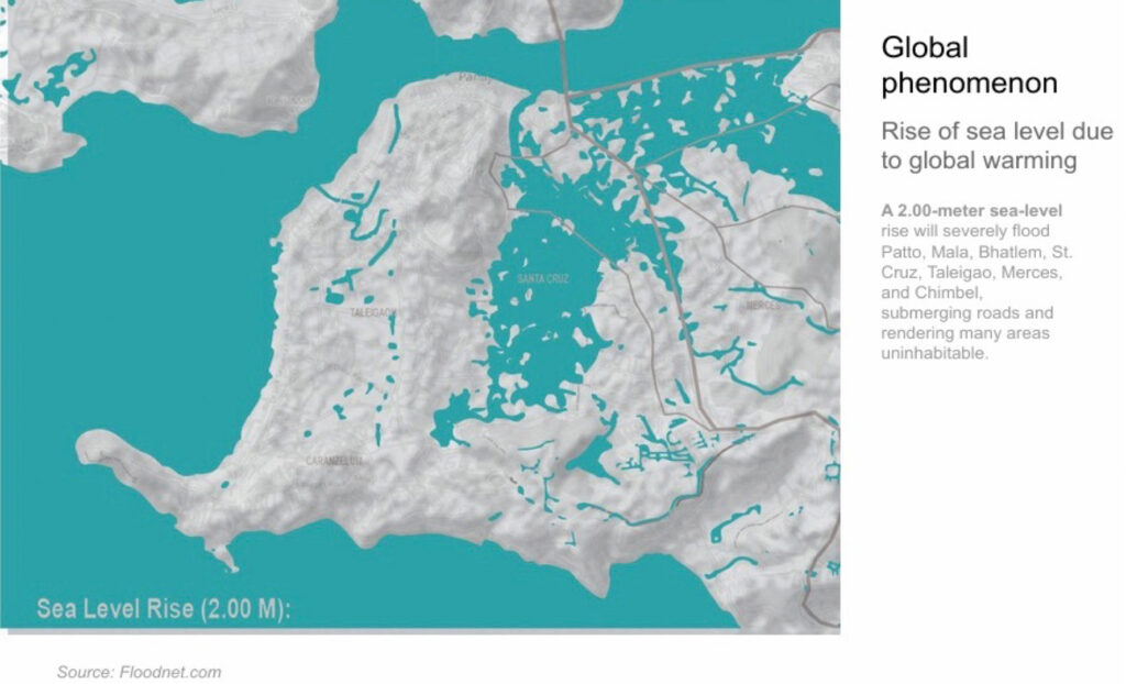
Fig. 14.4 Rise in sea level of 2 metres. Source: Khazans of Goa: Documentation and Mapping, M. Arch, Second Year, Goa College of Architecture, 2024.
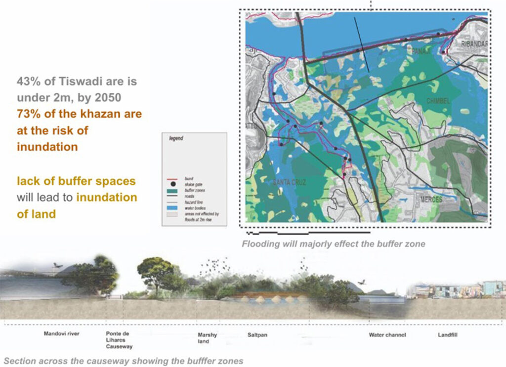
Fig. 14.5: Effects of 2-metre rise in sea level on khazans. Source: Khazans of Goa: Documentation and Mapping, M. Arch, Second year, Goa College of Architecture, 2024.
The catchment area in Panjim, as seen in Figure 14.2, has now been reduced, and the hydrology of nearby creeks has been disturbed. Runoff has been affected leading to the disruption of natural water flow, increased flood risk, and threatened local ecosystems. Also, many reports on climate change indicate the global phenomenon of sea level rise, as seen in Figures 14.3, 14.4 and 14.5, will be evident by 2050 and its effects will be seen locally in coastal cities including Panjim and its suburbs (Malkarnekar 2019).
4. Impact of Urbanization on Panjim and the Mhadei River
Analysis of urbanization trends shows a focus on tourism and infrastructure growth. Intense development pressures and urbanization in Panjim have resulted in severe ecological degradation of the region’s water systems, contributing significantly to various climate change-related issues. According to Alvares (2002), “The Agriculture Land Development Panel (ALDP) found in its survey that a number of ongoing developmental activities and the rapid socioeconomic changes since liberation have adversely affected these ecologically compatible and harmonious systems, i.e., mangrove forests and khazan lands. The activities include deforestation in upper river basins, uncontrolled urban growth, man-made pollution of estuaries, heavy barge traffic in the Mhadei and Zuari rivers, encroachments in wetlands/marshy lands, destruction, blockage or imperfect substitution of natural drainage systems, uncontrolled and illegal pisciculture, unauthorised extraction of sand, shells, etc. and the problem of slums, scrap yards and junk yards near estuarine areas” (Alvares 2002).
Once marked by a lush, green skyline, the upper Mhadei estuarine basin is now undergoing rapid transformation under these development pressures. Deforestation and effluent runoff have also led to the sedimentation of existing water basins. Tourism-driven activities, particularly the establishment of numerous casinos along the river basin, have taken over much of this area. Human interventions, such as geomorphic alterations at foothills and along wetland edges, have led to the neglect and contamination of the water-shed, blocking what was once an efficient stormwater drainage system. The dumping of sewage and garbage into rivers and creeks has also negatively impacted the ecosystem. Like other areas in Panaji, the entire drainage system of Fontainhas has been blocked due to the illegal reclamation of the ancient Fontainhas creek, which once connected to the Calapur-Ourem creek.

Fig. 14.6: The Evolution of Panjim. Source: Urban Imaginaries in the times of climate change: Placemaking for Panjim and its surroundings, M. UD., 2nd year, Goa College of Architecture, 2021.
As Nandkumar M. Kamat points out, “Flooding in Panaji is a price to pay for rapid rise in impervious areas in the name of beautification. The Portuguese had created large rain-soaking spaces in the form of gardens in the city and large open playgrounds, which can still be seen inside the Massano de Amorim old school complex and the police headquarters, as well as the courtyard in front of the old Lyceum. Before a large part was paved over, Azad Maidan, with its soft, sandy subsoil could absorb thousands of litres of rainwater per day. Concretization of Salvador de Souza Kranti Udyan near Dempo Mansion has resulted in surrounding areas flooding” (Kamat 2020).
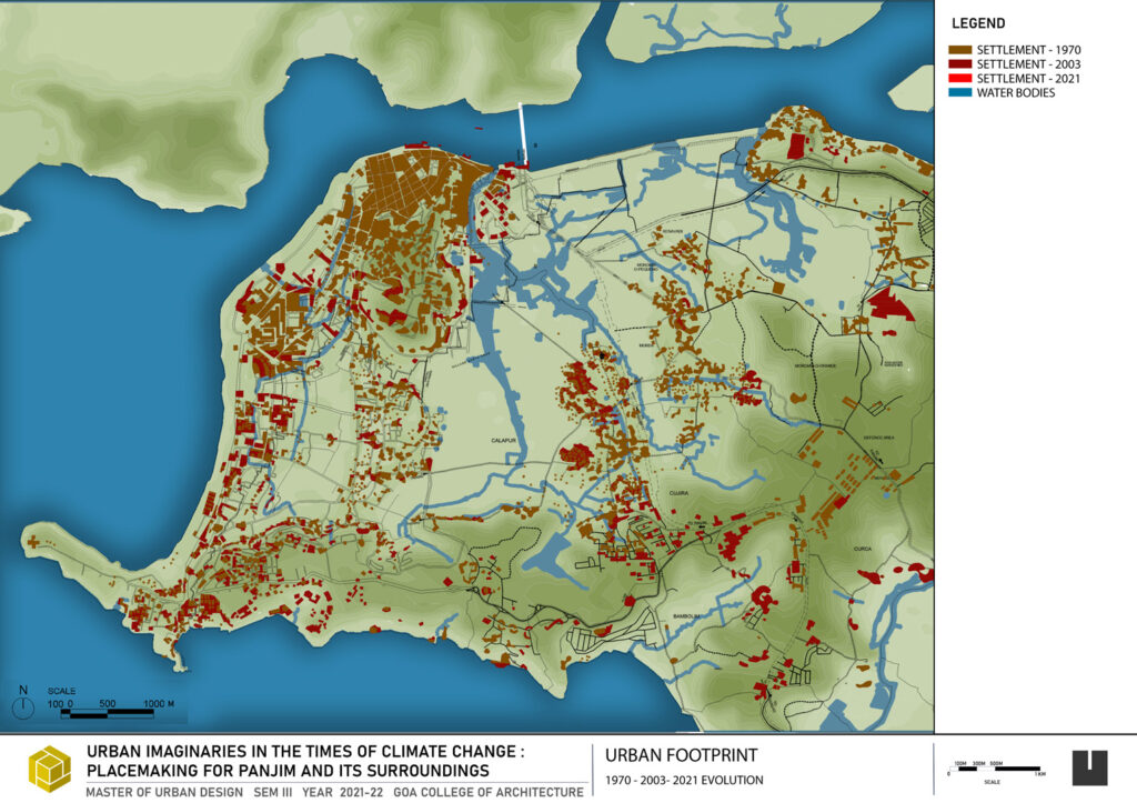
Fig. 14.7: Evolution of Panaji. Source: Urban Imaginaries in the times of climate change: Placemaking for Panjim and its surroundings, M. UD., 2nd year, Goa College of Architecture, 2021.
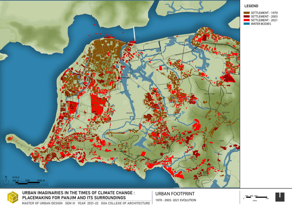
Fig. 14.8: Evolution of Panaji. Source: Urban Imaginaries in the times of climate change: Placemaking for Panjim and its surroundings, M. UD, 2nd year, Goa College of Architecture, 2021.
Panjim’s historical urban planning, which once prioritized flood mitigation through a grid pattern layout and a well-functioning drainage system, is now struggling under the weight of neglect and rapid urbanization as seen in Figures 14.6, 14.7 and 14.8. The city’s creeks—once vital drainage conduits—are now choked with silt and garbage, while fragmented drainage infrastructure has further worsened flood risks.
Addressing these issues requires a holistic approach that integrates traditional water management practices with modern urban planning solutions. Even as local authorities and engineers have initiated projects like building gutters, installing pumping stations, and constructing higher retaining walls along water bodies. These efforts often fail over time because they do not consider the overall estuarine ecosystem of the Mhadei River. Water is viewed as a problem, intruding into areas that have been developed despite historically belonging to its natural domain (Kamat 2020).
Manguesh Prabhugaonker (2019), then chairman of the Goa chapter of the Indian Institute of Architects, emphasized that old primary drains must be connected with newer secondary and tertiary drains to manage water flow effectively. He also recommended dredging the creeks and upgrading the drainage network. Experts criticized the lack of coordination between various authorities such as the Corporation of the City of Panaji (CCP), Public Works Department (PWD), and Department of Water Resources (WRD), which hinders flood management efforts. Patricia Pinto, former CCP councillor, pointed out that poor engineering on D.B. Road exacerbates waterlogging. Prabhugaonker also stressed that no new drains are needed, only improved connectivity between existing ones to solve the flooding issue (TNN 2019).
5. The Traditional Khazan System and its Role in Water Management / Mangroves
Khazans are the largest community-owned assets of Goa (Alvares 2002). These are saline floodplains in Goa’s tidal estuaries that were originally reclaimed from marshy coastal floodplains and mangroves along the rivers for agriculture by the indigenous Gauda tribes of Goa (Sonak 2014), creating the eco-engineered khazan farming system over centuries with an intricate system of bunds (dikes) and sluice gates, also including the depression called poiem or poim, which is at the lowest level of the low tide and acts as a repository for excess water as seen in Figure 14.9.
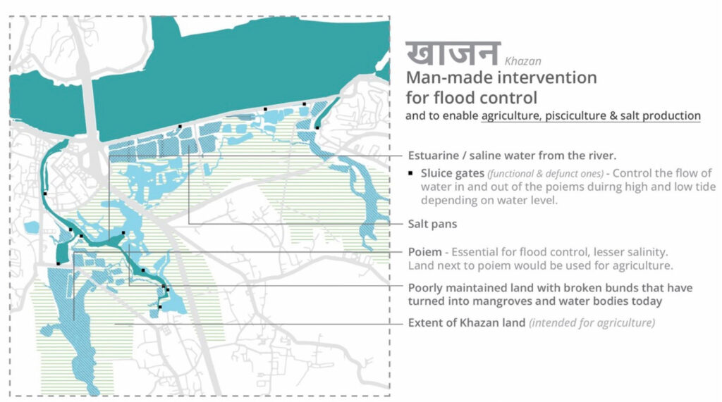
Fig. 14.9: Components of the khazan.
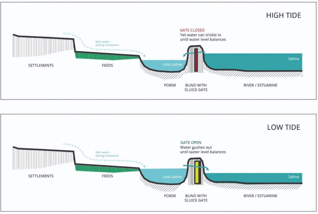
Fig. 14.10: Section through a Khazan. Source: Khazans of Goa: Documentation and Mapping, M. Arch, Second year, Goa College of Architecture, 2024.
These systems traditionally used materials such as clay, straw, poles, branches of trees, or locally available laterite and other stones, making them not only economical but also environment friendly. These gates operate on tidal power, primarily protect the khazans from inundation, and regulate inflow and outflow of tidal water, ensuring the rivulets are not totally drained at low tide (Alvares 2002). This system, which focused on regulating salinity and tidal flows, functioned similarly to modern “sponge city” practices by allowing the natural flow and filtration of water, essential for both agriculture and flood mitigation.
These khazans, primarily reclaimed mangrove areas that have vegetation close to the interior or exterior bunds, provide a crucial natural anti-erosion barrier. The role of mangroves in these systems cannot be overstated; they act as natural flood buffers and contribute to water quality management (Sonak 2014). This indigenous knowledge aligns with nature-based solutions (NBS) practices, which use natural ecosystems to manage urban water systems and reduce flood risks.
Extremely vulnerable components of the system include the biota of estuaries, mangrove swamps and woodlands, intertidal zones, mud flats, embankments, and khazan lands, all of which are closely tied to the Mhadei river’s tidal dynamics. These areas function as natural buffers, regulating tidal inflows and acting as stormwater storage facilities during extreme weather events. If these lands are destroyed or reclaimed, tidal exchange with the river is disrupted, leading to increased flooding in adjacent urban and agricultural zones. The sluice gates that additionally serve as emergency storm water receptacles are also affected by current development pressures, highlighting issues of mismanagement and leading to flooding in the surrounding area (Herald Team 2020).
Khazan ecosystem management is also currently hampered by various other challenges, including ecological pressures such as excessive mangrove growth and weed proliferation, natural threats like mud crab infestations and boring agents, and human-induced stresses such as intensive agriculture, mining, and other socio-economic factors. The declining connectivity between the khazans and the river has worsened these issues, as reduced tidal flushing accelerates sedimentation, alters salinity levels, and weakens the khazan embankments that historically relied on the controlled ingress and egress of estuarine waters.
Although there has been some work that has been undertaken by the state to preserve these bunds since liberation, Elsa Fernandes (2021) notes that traditionally local materials like clay, wooden poles, and cashew seed sap (dhik) were identified as the most frequently used materials in bund construction. The bund work undertaken by the government, however, has employed new materials and techniques, such as concrete, rubble stone pitching, and laterite mud filling. More than half the experts felt that the present bund conditions are very poor and do not help in tidal regulation. Fernandes also emphasises that there is no difference between the flooding protection provided by naturally existing land forms and the unique man-made bunds in the khazans of Goa if done correctly (Fernades, Kharve, and Kulkarni 2021).
One of the major setbacks leading to the decline in khazan land productivity is the mismanagement stemming from the introduction of the Tenancy Act of 1964. This Act shifted management from the traditional bous (brotherhood/collective) system to individual ownership for tenants through tenants’ associations, disrupting a well-evolved, sustainable management system. Further investigation into the role of governance structures and community participation in maintaining these landscapes would provide valuable insight for sustainable interventions for the future.
Changing the way water flows.
Currently, there is little to no consideration of the various issues and ground realities in the policy-making process concerning ecological systems. Most government departments work independently, with limited communication between departments, planners, environmental experts, policy-makers, etc. This fragmentation results in ecological systems being sidelined in decision-making processes, as the immediate priority tends to be economic development or infrastructure growth. Further research could examine how the integration of these disciplines could improve policy frameworks for sustainable urbanization.
The ongoing unregulated development also appears to violate Coastal Regulation Zone (CRZ) regulations, which aim to protect sensitive ecological areas from unchecked construction and environmental degradation. Wet-lands are rapidly disappearing, diminishing their ability to contain flooding. There is minimal pervious surface area available for stormwater absorption on Panjim’s reclaimed lands because they are mostly covered in concrete and asphalt. Additionally, new developments along the further restrict natural drainage, exacerbating urban flooding even during light rainfall as urban density increases (Ramanathan et al. 2021).
The shift towards urbanization, coupled with the effects of climate change, has further complicated flood management in Panaji. Rising sea levels, exacerbated by tidal effects, impact both the Mhadei River and its surrounding wetlands, escalating flood risks. While urban expansion has yielded economic gains, the long-term environmental costs are increasingly apparent. The absence of comprehensive flood management strategies, including nature-based solutions like the revival of the khazan system, worsens both ecological degradation and the challenges posed by urbanization. Revisiting Panjim’s historical waste management dependency on the Mhadei River could be key to formulating sustainable solutions.
6. Groundwater Recharge, Availability, and Salinity
In Panjim, once rainwater percolates into the ground, it is primarily stored in laterite and alluvial aquifers, similar to most of Goa. Groundwater recharge here is highly dependent on annual monsoon rains, which contribute significantly to replenishing local aquifers. However, urbanized areas like Panjim experience lower recharge rates due to impervious surfaces (such as concrete) that hinder infiltration, as mentioned earlier. Furthermore, while laterite soils allow for rapid groundwater recharge, they also facilitate faster depletion, particularly during dry spells (Central Ground Water Board 2010).
One major challenge concerning groundwater in Panjim is salinity intrusion. As with other coastal areas in Goa, seawater intrusion becomes problematic during dry months when freshwater flow in the rivers decreases as seen in Figure 14.11. The Mhadei and its tributaries play a critical role in the region’s groundwater recharge, but during summer, reduced river flow allows increased seawater ingress into the aquifers, leading to brackish groundwater. This directly impacts the city’s groundwater quality, especially in areas near the coastline or river mouths (Central Ground Water Board 2010).
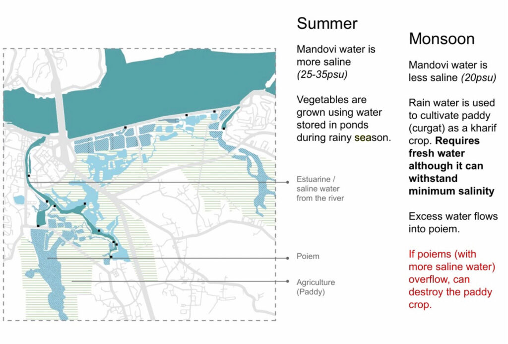
Fig. 14.11 Khazans and Salinity. Source: Khazans of Goa Documentation and Mapping, M. Arch, Second year, Goa College of Architecture.
In addition to salinity, pollution from domestic sewage further threatens groundwater quality, particularly in riverbank and urban areas. The city’s wastewater management systems play a crucial role in maintaining water quality, yet inefficiencies in sewage treatment often contribute to contamination of both surface and groundwater sources.
7. Nature-Based Solutions and the Sponge City Concept in Panjim
Many urban centres face growing challenges from flooding, water scarcity, and environmental degradation, as seen in Panjim. These issues, exacerbated by rapid urbanization and climate change, demand innovative and sustainable solutions. Two prominent approaches—engineered solutions and nature-based strategies—offer distinct ways to tackling these challenges. Two case studies of the Thames river redevelopment in London and China’s Sponge City initiative as seen in Wuhan, Chongqing, and Shenzhen, illustrate their respective methodologies, benefits, and tradeoffs.
The Thames river redevelopment is an engineering solution, demonstrating how infrastructure can address urban water challenges. London, historically prone to flooding due to its low-lying location in southeastern England and its positioning along the tidal Thames, faced increasing risks from rising sea levels and storm surges. In response, the Thames Barrier was constructed and completed in the year 1982. This massive flood control system consists of steel gates that can be raised to block tidal surges from flooding London. Additionally, an extensive network of stormwater drainage systems and pumping stations manages the inland flooding. Over the last forty years, the barrier has been activated over 200 times, underscoring its critical role in protecting the city.
Engineered solutions like the Thames Barrier offer precision and high-impact protection against urban flooding. They incorporate advanced technology and materials, ensuring resilience in the face of acute environmental threats. However, such solutions come with drawbacks. Their high construction and maintenance costs, dependence on energy, and susceptibility to operational failures make them vulnerable. Moreover, prioritizing functionality over ecology disrupts natural ecosystems and landscapes.
Conversely, China’s sponge city initiative champions nature-based solutions over purely engineered approaches. The “sponge city” concept, introduced by architect Kongjian Yu in the year 2000, gained national importance in the year 2014 when the Chinese government formally adopted it to manage urban flooding, water scarcity, and pollution. This initiative emphasizes green infrastructure that mimics natural processes, integrating it seamlessly into urban landscapes. Sponge cities use permeable pavements, rain gardens, urban wetlands, green roofs, and vegetative buffers to absorb, store, and reuse rainwater. By reducing surface runoff and increasing groundwater infiltration, these features mitigate flooding while simultaneously addressing urban water shortages.
One of the most notable examples of the sponge city initiative is Wuhan, a city frequently plagued by flooding due to its location at the confluence of the Yangtze River and several lakes. Through the sponge city program, Wuhan implemented over 400 projects, including wetlands, bioswales, and rainwater harvesting systems. These interventions have drastically reduced flooding, improved water quality, and enhanced urban biodiversity, making Wuhan a global model for sustainable urban development.
Applying Nature-Based Solutions to Panjim
As climate change and urbanization continue to affect Panjim, incorporating nature-based solutions (NbS) is essential for the city’s long-term resilience. By restoring wetlands and mangrove ecosystems, NbS provides sustainable flood mitigation while offering co-benefits such as improved air quality, reduced urban heat islands, and enhanced recreational spaces. Additionally, these approaches encourage community engagement and environmental stewardship. Globally, cities like Wuhan (China), and Copenhagen (Denmark) have successfully implemented sponge city concepts, merging green infrastructure with conventional water management strategies to reduce flood risks and enhance urban sustainability.
Panjim presents an opportunity to develop a hybrid model, blending traditional systems with contemporary planning approaches. Historically, the city relied on the khazans (traditional water systems) and mangroves to regulate water flow and prevent flooding. However, urbanization and tourism-driven expansion have significantly strained these systems. To counteract this, recent initiatives include:
- Mangrove restoration projects
- Enhanced drainage networks
- Implementation of green infrastructure solutions
The Mhadei river, once central to Panjim’s ecological resilience, remains critical to future adaptation strategies. Integrating sponge city principles—such as permeable pavements, bioswales, and urban wetlands—can help absorb excess rainwater while reducing the burden on the city’s traditional drainage system. For instance, revitalizing Panjim’s khazan system, which originally served as an eco-engineered solution to manage salinity and tidal water, could be a key component in a modern sponge city strategy. These restored ecosystems would not only mitigate seasonal flooding but also enhance bio-diversity and long-term environmental health.
Integrating NbS alongside engineered flood-management solutions—similar to Seoul’s Han River model—could help Panjim balance development with ecological sustainability, mitigating flood risks, while preserving its natural heritage. Panjim’s estuarine setting offers opportunities to blend NbS with traditional engineering approaches. Strategic interventions can reduce flood risks, enhance water quality, and protect the Mhadei river from further degradation. In the long term, NbS provide more sustainable flood mitigation than relying solely on engineered solutions. These strategies not only improve water management but also enhance the quality of life for residents by creating healthier, more liveable urban spaces.
Strategies for Panjim: A Localized Approach
Developing a sustainable urban water management framework for Panjim requires tailored solutions that integrate NbS with engineering interven-tions. A phased approach to planning and implementation will ensure long-term effectiveness.
-
Policy and Planning-Level Interventions
At a policy level, Panjim’s flood resilience strategy must integrate ecological preservation with urban planning. Key measures include:
- Stronger Coastal Regulation Zone (CRZ) Enforcement: Ensuring that urban development complies with CRZ guidelines to prevent further encroachment on floodplains, wetlands, and mangroves
- Zoning Regulations for Sustainable Development: Implementing land-use policies that prioritize green spaces, flood buffer zones, and permeable infrastructure in urban expansion projects
- Integration of NbS in Urban Master Plans: Formalizing the use of nature-based interventions, such as rain gardens, bio-swales, and permeable pavements, in new development projects
-
-
Combining NbS with Engineered Solutions
-
A hybrid approach can maximize Panjim’s resilience to flooding, balancing traditional infrastructure with ecological restoration. Key strategies include:
- Reviving the Khazan System: Restoring Panjim’s traditional tidal water management system to regulate salinity levels and improve water retention in coastal areas
- Mangrove Restoration Along the Mhadei River: Strengthening natural flood barriers by rehabilitating degraded mangrove ecosystems to enhance stormwater absorption and erosion control
- Upgrading Natural Drainage Systems: Enhancing existing drainage networks to prevent waterlogging while integrating green stormwater management solutions such as bioswales and retention ponds
- Sponge City Elements: Implementing green infrastructure interventions like permeable pavements, rooftop gardens, and urban wetlands to enhance water infiltration and groundwater recharge
-
Implementation and Phasing
A phased approach ensures that interventions are practical and sustainable.
- Short-term (0–2 years): Immediate measures include policy enforcement, small-scale pilot projects for rain gardens and permeable surfaces, and improving waste and sewage
- Medium-term (3–5 years): Large-scale NbS projects, including wet-land restoration, khazan system rehabilitation, and flood-resilient urban design, should be
- Long-term (5+ years): Integrating sustainable water management principles into all future urban planning and continuously monitoring ecological and hydrological
Challenges and Management Considerations
Panjim faces multiple challenges in implementing these solutions, requiring a proactive approach to water resource management.
- Seawater Intrusion: The intrusion of seawater into groundwater, particularly in summer months when river flow is lowest, threatens fresh-water Strengthening natural recharge systems and limiting excessive groundwater extraction can mitigate this issue.
- Pollution Control: Untreated domestic sewage is a significant contaminant of both groundwater and surface Upgrading wastewater treatment infrastructure and enforcing pollution control regulations is critical.
- Water Conservation: Given Panjim’s reliance on seasonal monsoons for groundwater recharge, conservation measures such as rainwater harvesting, wastewater recycling, and the construction of percolation ponds should be prioritized.
Conclusion
Panjim’s hydrogeological challenges require a balanced approach that integrates traditional ecological practices with modern urban planning strategies. By reinforcing natural floodplain dynamics and restoring critical water systems like khazans and mangroves, the city’s estuarine ecology along with its relationship to the Mhadei river cannot be maintained unless improved for long-term resilience to climate change and urbanization pressures. A well-structured, phased implementation plan will ensure that nature-based solutions are effectively integrated with engineered infrastructure, securing Panjim’s ecological health and water security for the future.
References
Alvares, Claude. 2002. Fish, Curry and Rice. 4th ed. Panaji: Goa Foundation.
Araral, Eduardo. 2014. “Ostrom, Hardin and the Commons: A Critical Appreciation and a Re-visionist View.” Environmental Science & Policy 36 (February): 11–23. https://doi.org/10.1016/j. envsci.2013.07.011.
Becker, C. Dustin, and Kabita Ghimire. 2003. “Synergy Between Traditional Ecological Knowl-edge and Conservation Science Supports Forest Preservation in Ecuador.” Conservation Ecology 8
(1). https://doi.org/10.5751/ES-00582-080101.
Boelens, Rutgerd, Arturo Escobar, Karen Bakker, Lena Hommes, Erik Swyngedouw, Barbara Hogenboom, Edward H. Huijbens, et al. 2023. “Riverhood: Political Ecologies of Socionature Commoning and Translocal Struggles for Water Justice.” The Journal of Peasant Studies 50 (3): 1125–56. https://doi.org/10.1080/03066150.2022.2120810.
Bouissou, Julien. 2011. “Popularity Threatens to Turn a Once Romantic Destination into a Sewer.” The Guardian, August 23, 2011.
Central Ground Water Board. 2010. “Ground Water Information Booklet North Goa District, Goa State.” Ministry of Water Resources, Government of India.
Central Pollution Control Board. 2013. “Water Quality Data Year 2013 – Medium and Minor Rivers (State-Wise).” Accessed June 2, 2025.
https://cpcb.nic.in/wqm/2013/MEDIUMANDMINORRIVERDATA2013 32.htm.
Charles Correa Foundation. n.d. “Expansion of Panaji (1510–1983) – Goa through Maps.”
Choi, Christy. 2024. “‘Sponge’ Cities Combat Urban Flooding by Letting Nature Do the Work” CNN , August 13, 2024.
City Population. n.d. “Panaji (North Goa, India) – Population Statistics.” https://www. citypopulation.de/en/india/goa/north goa/3040120000panaji/.
Corte´s-Espino, Aurora, Alfonso Langle-Flores, and Carlos Gauna Ru´ız De Leo´n. 2023. “Valuing Free-Flowing Rivers: The Influence of Social Value on Willingness to Pay for Ecosystem Services Protection.” Water 15 (7): 1279. https://doi.org/10.3390/w15071279.
D’Cruz, Dolcy. 2023. “The History of Panjim City’s Resilience against All Odds.” O Heraldo, Septem-ber 29, 2023.
D’Silva Dias, Chryselle. 2023. “The Freshwater Springs That Dot Panaji.” Paper Planes, June 30, 2023.
Das, Arti. 2023. “River Mhadei: Facts, Figures and Art in Goa | The Bridge Chronicle.” Gomantak Times, April 30, 2023.
“Drain the Rain: Why Urban India Floods, How to Build Sponge Cities – Question of Cities.” 2023. Question of Cities, June 30.
Environment Agency. 2025. “The Thames Barrier.” https://www.gov.uk/government/ organisations/environment-agency.
ETGovernment. 2022. “Panaji Smart City Plans Beautification of Ribandar with Streetscape Design, Plazas, Sewerage Network at Rs 61.5 Cr.” ETGovernment , March 14, 2022. https:
//government.economictimes.indiatimes.com/news/smart-infra/panaji-smart-city-plans-beautification-of-ribandar-with-streetscape-design-plazas-sewerage-network-at-rs-61-5-cr/ 90195260.
De Souza, Gerard. 2024. “Goa’s Low-Lying State Capital to Build Defences against Sea Level Rise.” Hindustan Times, March 12, 2024. https://www.hindustantimes.com/cities/others/goas-low-lying-state-capital-to-build-defences-against-sea-level-rise-101710229817661.html.
Fernandes, Elsa, Sujata Karve, and Prajakta Kulkarni. 2022. “Issues Affecting the Unique Bund Systems in the Khazans of Goa.” Paper presented at the National Online Conference on Planning, Design & Management (NOCPDM-2021), Goa.
Fernandes, Paul. 2023. “Khazans, a Unique but Crumbling Heritage Ecosystem.” Gomantak Times, September 29, 2023. https://www.gomantaktimes.com/news/goa/khazans-a-unique-but-crumbling-heritage-ecosystem.
Florian, Maria-Cristina. 2023. “Landscape Architect Kongjian Yu, Pioneer of the ‘Sponge City’ Concept, Wins the 2023 Oberlander Prize.” ArchDaily, October 18, 2023. https:
//www.archdaily.com/1008480/landscape-architect-kongjian-yu-pioneer-of-the-sponge-city-concept-wins-the-2023-oberlander-prize.
Goa College of Architecture Urban Design Studio, M. Arch. 2024. “Khazans of Goa Documentation and Mapping.” Unpublished.
Gottwald, Sarah, Christian Albert, and Nora Fagerholm. 2022. “Combining Sense of Place Theory with the Ecosystem Services Concept.” Landscape Ecology 37 (2): 633–55. https://doi.org/10.1007/ s10980-021-01362-z.
GT Digital. 2023. “Will Smart City Panjim Flood or Will Not, This Monsoon?” Gomantak Times, June 22, 2023.
Herald Team. 2022. “Pollution in Rivers Declines but Still Unsafe for Bathing.” O Heraldo, Decem-ber 25, 2022.
———. 2023. “Sewerage ‘Mess’ in Smart City Panjim.” O Heraldo, June 10, 2023. https://www. heraldgoa.in/Review/Sewerage-mess-in-Smart-City-Panjim/205972.
ICE (Institution of Civil Engineers). 2024. “Thames Barrier.” Institution of Civil Engineers. Accessed June 2, 2025. https://www.ice.org.uk/what-is-civil-engineering/infrastructure-projects/thames-barrier.
ICLEI, South Asia. 2023. Panaji: City Information Note. Pune: ICLEI South Asia. July 19, 2023. https:
//southasia.iclei.org/wp-content/uploads/2023/07/Panaji-City-Information-Note.pdf
———. 2024. Goa’s Khazans—A Unique Guard Against Climate Change. Prepared under the Azim Premji University Supported Project on the Need for an Urban Policy on Khazans—Ensuring Sus-tainable and Climate-Resilient Urban Development. August 13, 2024. https://southasia.iclei.org/ publication/goas-khazans-a-unique-guard-against-climate-change/.
IUCN. 2017. “Mangroves: Nurseries for the World’s Seafood Supply.” August 24, 2017. https://iucn. org/news/forests/201708/mangroves-nurseries-world’s-seafood-supply.
Iyer, Ramaswamy R. 2011. “National Water Policy: An Alternative Draft for Consideration.” Eco-nomic and Political Weekly 46, no. 26–27 (June 25, 2011). https://www.epw.in/journal/2011/26-27/review-agriculture-review-issues-specials/national-water-policy-alternative-draft
Jacob, George Jerry. 2018. “The Khazans of Goa: A Socio-Cultural Perspective.” Sahapedia. Ac-cessed June 2, 2025. https://www.sahapedia.org/khazans-goa-socio-cultural-perspective.
———. 2024. “Khazans: Traditional Water Management System of Goa.” Sahapedia. Accessed June 2, 2025. https://www.sahapedia.org/khazans-traditional-water-management-system-goa.
Jnana Foundation. 2023. “Khazan Project.” https://jnanafoundation.org/khazan-project.
Kamat, Nandkumar M. 2004. “History of Khazan Land Management in Goa: Ecologi-cal, Economic and Political Perspective.” Paper presented at the Seminar on the History of Agriculture in Goa, Department of History, Goa University, March 12–13, 2004. https:
//www.researchgate.net/publication/283475605 History of Khazan land management in Goa ecological economic and political perspective.
Malkarnekar, Gauree. 2019. “Goa: Tiswadi, Bardez to Lose Major Chunks to Sea Level Rise by 2050.” The Times of India, October 31, 2019. https://timesofindia.indiatimes.com/city/goa/ tiswadi-bardez-to-lose-major-chunks-to-sea-level-rise-by-2050/articleshow/71827957.cms.
Mendes, Sushila Sawant. 2022. “Goa Remained a Portuguese Colony When India Became Indepen-dent.” The Wire, August 17, 2022. https://thewire.in/history/goa-remained-a-portuguese-colony-when-india-became-independent.
Kamat, Nandkumar M. 2020. “History of Panaji’s Destroyed Drainage.” The Navhind Times, June 26 2020.
Navhind Times. 2014. “Floods: The Worse Is yet to Come.” The Navhind Times, September 7, 2014.
———. 2015. “Domestic Sewage Main Mandovi Pollutant.” The Navhind Times, August 9, 2015.
———. 2023. “Panaji Struggles with Sewage Mgmt, Sees 3,261 Sewer Overflow Cases.” The Navhind Times, November 27, 2023.
Nikeita Saraf, and Jashvitha Dhagey. 2024. “From St. Inez Creek to Goa’s Stories of Water Sys-tems.” Charles Correa Foundation, November 18, 2024.
Noronha, Oscar de. 2022. “In Memories, Panjim.” November 9.
PTI. 2024. “Wastewater Contributing to Microplastics in Mandovi River.” ThePrint – PTI Feed, March 18, 2024.
Ramaiah, N., V. Rodrigues, E. Alvares, C. Rodrigues, R. Baksh, S. Jayan, and C. Mohandass. 2007. “Sewage-Pollution Indicator Bacteria.” In The Mandovi and Zuari Estuaries, edited by S. R. Shetye,
- Sundar, and G. S. Michael, 115–121. Goa: National Institute of Oceanography. https://drs.nio. res.in/drs/handle/2264/634.
Rose, Carol M. 2020. “Thinking about the Commons.” International Journal of the Commons 14
(1): 557–66. https://doi.org/10.5334/ijc.987.
Sawkar, Kalidas, Ligia Noronha, Antonio Mascarenhas, O. S. Chauhan, and Simad Saeed. 1998. “Tourism and the Environment: Case Studies on Goa, India, and the Maldives.” World Bank Insti-tute.
Sharma, Yogesh Kumar. 2020. “Impact of Tourism Through the Real Estate (Construction) Sector on the Coastal Environment of Goa.” International Journal of Engineering Research 9 (11).
Sonak, Sangeeta M. 2014. Khazan Ecosystems of Goa: Building on Indigenous Solutions to Cope with Global Environmental Change. Dordrecht: Springer Netherlands. https://doi.org/10.1007/ 978-94-007-7202-1.
Team Herald. 2024. “Why Can’t Panjim’s ‘Smart’ Bosses Do This Much?” O Heraldo, July 10, 2024.
The Goan Network. 2024. “2 Old Drainage Systems Being Restored to Mitigate Flooding.” The Goan EveryDay, April 1, 2024.
The Goan EveryDay. 2024. “Shot in the Arm for Khazans at Panaji, Taleigao, St Cruz.” 2024. The Goan EveryDay, February 26, 2024.
Times of India. 2020. “State River Panel Acts Tough on Sewage Discharge into Mandovi.” Times of India, May 10, 2020.
———. 2024. “90% of Sewerage, Infra Work Done: Imagine Panaji.” 2024. Times of India, June 2, 2024.
TNN. 2019a. “Vicious Cycle: Sewage Released into Rivers Affects the Very Water We Drink.” Times of India, June 14, 2019.
———. 2019b. “Behind Panaji Floods: Failure to Connect Drains, Choked Creeks.” Times of India, July 26, 2019.
———. 2022. “Goa’s Smart City Turns Swamped City as Panaji Gets Deluged yet Again.” Times of India, July 5, 2022.
———. 2023. “Sewerage Coverage in Goa 16%, Way Short of National Average of 28%.” Times of India, January 24, 2023.
Toraskar, Ashwini D., Cathrine S. Manohar, Charmaine L. Fernandes, Durbar Ray, Abigayle D. Gomes, and Ajit Antony. 2022. “Seasonal Variations in the Water Quality and Antibiotic Resistance of Microbial Pollution Indicators in the Mandovi and Zuari Estuaries, Goa, India.” Environmental Monitoring and Assessment 194 (2): 71. https://doi.org/10.1007/s10661-021-09679-7.
Trichur, Raghuraman. 2013. Refiguring Goa: From Trading Post to Tourism Destination. Goa, 1556.
United Nations Environment Programme. 2023. “An Inside Look at the Beauty and Benefits of Mangroves.” UNEP, July 25, 2023. https://www.unep.org/news-and-stories/story/inside-look-beauty-and-benefits-mangroves.
Figure Credits
Bhave, Pradnya, Anali Dacosta, Veleni Dcosta, Greig Fernandes, Sidhanti Parab, and Vibhavari Shi-rodkar. 2021. “Urban Imaginaries in the Times of Climate Change: Placemaking for Panjim and Its Surroundings.” Goa College of Architecture, M.Arch Urban Design Studio. Unpublished.
Gupta, Astha, Rajas Parsekar, Ritu Shelar, Rishav Paul, and Sudharsha Subbiah. 2024. “Khazans of Goa: Documentation and Mapping.” Goa College of Architecture, M’Arch Urban Design Studio. Unpublished.
Author Profile
Leon Morenas is the Principal of the Goa College of Architecture. He was Associate Professor of Architecture at the School of Planning and Architecture, Delhi. He was also a Fellow at the Indian Institute of Advanced Study, Shimla where he worked on a project entitled “Mohallas and Smart Cities: Post-Colonial Development in Delhi.” He was a World Social Sciences Fellow in Sustainable Urbanization (2014) and Programme Coordinator of the Masters in Social Design at Ambedkar University, Delhi (2013). He is an architect with a Master’s in Urban Design from the School of Planning and Architecture, Delhi and a PhD in Architectural Sciences—with a specialization in Informatics—from Rensselaer Polytechnic Institute, Troy, New York. Professor Morenas’s research uses the disciplinary lens of Science and Technology Studies (STS) to understand the relationship of technology with contemporary design, architecture and urban planning. His most recent writings have focused on urban governance through technology with a focus on smart cities and their command centres. He is also working on a set of essays that attempt to answer the question: “Is there an Indian way of thinking about technology?” using the foils of history, metaphysics and literature.
Manisha Rodrigues is an architect based in Goa. She holds a Bachelor’s degree from the Goa College of Architecture and aMaster’s in Architecture with a specialization in architectural conservation from CEPT University, Ahmedabad. With over a decade of experience in practice and more than three years as an assistant professor at her alma mater, the Goa College of Architecture, her work often explores the intersections of water, heritage, and the built environment. She was part of projects like the Serampore Initiative led by the National Museum of Denmark, which documented Indo-Danish heritage along the Hooghly River. Her academic and professional work reflects a deep connection to water and cultural landscapes—from the Sabarmati and Hooghly to the Sal and Mandovi rivers in Goa. As a fellow of the Goa Water Stories fellowship by the Living Waters Museum, she explored “What is a river?” through the lens of the built environment of the Mhadei–Mandovi– Mahadayi River. She currently leads her practice in Margao and continues to engage with architectural education as visiting faculty at the Goa College of Architecture.