Chapter: 9
Understanding Mhadei River Water Sharing
A. G. Chachadi
Abstract
Relying on information and data taken from existing literature, this chapter exposes gaps in the existing arguments about the diversion of the Mhadei’s water and seeks to evolve new ideas and thinking about the topic. It begins with a summary of the Mhadei river basin’s properties, rainfall, and water availability in the Introduction. Aspects related to base flow estimation and its temporal availability in the Mhadei river watershed, and groundwater studies related to groundwater flow pattern and its interaction with the Mhadei river and its impacts on diversion are discussed in the next section. This is followed by a discussion on the water allocations by the Mahadayi Water Disputes Tribunal to the contesting states. This in turn leads to post-project changes arising in the lower part of the basin, which are discussed in the section on the likely impacts of water diversion on the lower reaches of Mhadei river. Using field-based scientific studies and numerical modeling data, the chapter proposes new ideas to minimize ecological damage by suggesting changes in the existing water allocations and dam site locations for diversion structures. The chapter concludes with an assessment of the way forward, discussing the latest research findings based on model simulation by experts to address contentious issues and provide solutions to the vexed water sharing issue. Some of these points should act as guiding principles for furthering the deliberations by the Tribunal, the contesting parties, and public for better utilization of the assets created and protection of the interests of the lower riparian state and overall ecosystem.
Introduction
THE natural resources of air, water and soil should not be utilized if the utilization results in irreversible damage to environment.
There has been accelerated degradation of the environment primarily on account of lack of effective enforcement of environmental laws and non-compliance with statutory norms. Constructing dams or diversion projects across rivers is hazardous in nature. They impair the ecology and people’s right to natural resources. Setting up and maintaining dams, reservoirs, and inter-basin transfer projects require the utmost good faith and honesty on the part of those who propose these constructions. Such constructions tend to degrade the environment and are likely to affect air, water and soil and impair the quality of life of the inhabitants of the area. Full disclosure of the potential for increased burden on the environment consequent upon possible increase in the quantum and degree of pollution has to be made at the outset so that the public and the authorities concerned can make informed decisions about whether or not permission should be granted for such large constructions.
Balancing the needs of development and the protection of ecology is important. The ecocentric approach includes ecosystems, flora, fauna, and humans, whereas the anthropocentric approach gives humas priority above flora and fauna, which can have devastating effects on river ecology. National Water Policy, 2012, states that “Inter-basin transfers are not merely for increasing production but also for meeting basic human needs and achieving equity and social justice. Inter-basin transfers of water should be considered on the basis of merits of each case after evaluating the environmental, economic and social impacts of such transfers” (Government of India 2012).
When a river system drains more than one state the task of equitable distribution of its water resources becomes difficult and questionable. Harnessing of the river water by the riparian states in the upper reaches of the watershed often leads to inter-state conflicts. Several inter-state river water disputes are taking place across India. Despite the fact that sharing is inevitable the question of how much water to be shared is always debatable.
The river Mandovi is an inter-state river that originates in the Western Ghats and flows down the entire width of the state of Goa to discharge into the Arabian Sea. The Mandovi river basin extends over an area of about 2,017 sq. km, of which 1,551 sq. km (77 percent) lies in Goa, 394 sq. km (19.5 percent) lies in Karnataka and the remaining 72 sq. km (3.5 percent) lies in the Maharashtra (Ibrampurkar 2012). It is regarded as the lifeline of Goa as its watershed covers about 42 percent of the total area of the state, resulting in an extensive use of its water for drinking and agriculture purposes. The Mandovi river also serves as an important internal navigation route for commercial purposes. The Mandovi river basin has been divided into five watersheds namely Mhadei, Khandepar, Valvanti, Mapusa, and Sinquerim.
The Mhadei river watershed is a subcatchment of the Mandovi river basin.
The Mhadei river and the Khandepar river are the two major tributaries of the Mandovi river which drains into the Arabian Sea. The Mhadei watershed extends over a total area of 899 sq. km of which 573 sq. km (64 percent) lies in Goa and 326 sq. km (36 percent) lies in Karnataka, making it an inter-state watershed. The Mhadei river watershed is dominantly located in North Goa district. Valpoi is the only major town of Goa that is located within the watershed along with 68 villages. Out of these, 62 villages are located in Sattari taluka, three villages in Sanguem taluka, two villages in Ponda taluka and one village in Bicholim taluka. The land use and land cover estimation has indicated that almost 85 percent of the Mhadei watershed is covered by forest while about 4 percent is agricultural land. As per the revised estimates submitted to the Mhadei Water Disputes Tribunal (MWDT) by the Water Resources Department (WRD), Government of Goa, the total length of the Mhadei river is 111 km of which 35 km flows in Karnataka and 76 km flows in Goa. Kotrachi nadi (also called Veluz nadi), Surla nadi (also called Nanoda nadi) and Ragada nadi form the main tributaries of the Mhadei River. At Usgao, the Mhadei river meets the Khandepar River and is called as the Mandovi river from this point onwards as it flows towards the Arabian Sea.
The Mhadei river has been at the crux of a controversy since the 1980s because the Karnataka government has proposed the construction of three river water retention and diversion structures (dams and channels/water conduits respectively) in the upper reaches of the Mhadei river in Karnataka. The state of Goa has expressed concern about the likely effects of such river water retention and diversion structures on the hydrological regime, ecological balance, and economic development in the lower reaches of the Mhadei River watershed and the Mandovi River basin.
Earlier the Karnataka Government proposed six water retention structures covering a total catchment area of about 198 sq. km, which comprises 61 percent of the Mhadei watershed in Karnataka and 22 percent of the Mhadei river watershed in total. The Kalasa and Bhandura dam reservoirs will be connected to the Malaprabha river to divert the water. The total volume of rainwater that will be captured in the catchments of all the proposed six water retention structures is estimated to be 21 percent of the total volume of annual monsoon rainfall received in the entire Mhadei river watershed (Ibrampurkar 2012).
Over 90 percent of the rainfall in the area occurs during the monsoon months from June to September (wet season). The monsoon rainfall is characterized by bursts implying, that there is considerable high-frequency variability in runoff; in other words, a large fraction of the peak runoff during July–August can be expected to occur within a few days.
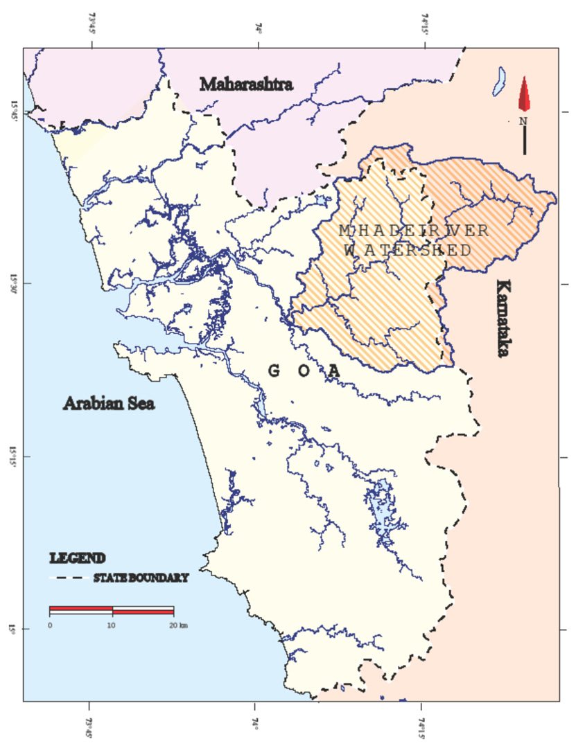
Fig. 9.1: Map showing the location of Mhadei river watershed.
The average rainfall in the Goa region of the Mhadei river watershed is computed as 4,160 mm while that in the Karnataka region of the watershed is 3,536 mm. About 84 tmcft (thousand million cubic feet), i.e., 67 percent of the rainwater is received by the Goa region of the Mhadei watershed while 41 tmcft i.e., 33 percent of rainwater is received by the Karnataka region of the Mhadei watershed. The total volume of rainwater received in the Mhadei river watershed is 125 tmcft, including 8.6 tmcft of non-monsoon rainfall. The average annual runoff at Ganjem is 120 tmcft as estimated by the National Institute of Oceanography, Goa. The National Water Development Agency (NWDA 1989) estimated 53.6 tmcft as usable water in the Mhadei river basin and similar estimates were proposed by Goa government. However, the Mhadei Water Disputes Tribunal (MWDT) estimated 188 tmcft of water at 75 percent dependability using a 40-year time series flow. This value as assessed by the Tribunal is considered as the basis for the allocation.
Runoff in the Mandovi increases almost twofold from Ganjem to Panaji (Suprit and Shankar 2007). A large fraction of this increase—about 84 percent—comes from the tributaries Khandepar (about 45 percent), Valvat (about 25 percent, including the Dicholi and Kudnem rivers), and the Mhapsa/Mapusa (about 14 percent, including the Moide and Asnoda rivers). The balance 16 percent flows directly into the estuary from the land adjoining it. This model estimate and analysis is relevant in the present context in relation to the total volume of Mhadei river water diversion by Karnataka.
Mhadei Watershed Base Flow Estimation, Groundwater Flow Pattern

Fig. 9.2: Components of total river runoff.
It is significant in the deliberations of the Tribunal that none of the contesting parties have taken into account the important aspect of base flow or dry weather flow in the Mhadei river. It is this water availability in the non-monsoon months from November to May that is a vital component of irrigation, drinking water, groundwater recharge, and its availability in the neighborhood of the river reach. Chapter 2 of Ibrampurkar’s (2012) PhD thesis includes an elaborate study on this aspect, which can be taken into account by the contesting parties and the MWDT. The total river runoff is a function of three components, namely, overland flow, interflow, and base flow. These three components of total runoff are shown schematically alongside.
In order to estimate the dry weather flow coming from the Karnataka region of the watershed, stream-flow measurements were carried out on the Mhadei river at the Goa-Karnataka state boundary near village Uste by Ibrampurkar in the months of December 2007 and April 2008 using the velocity-area method. Thus, the discharge measured in the months of December 2007 and April 2008 is respectively 0.035 tmcft/month (36 percent of total base flow measured at Ganjem) and 0.0029 tmcft/month (32 percent of total base flow measured at Ganjem). The average base flow discharge computed at Ganjem river gauging station for the month of December 2007and April 2008 are 0.096 TMCft/month and 0.009TMCft/month respectively.
The total non-monsoon (October to May) baseflow contribution from the Karnataka watershed of the Mhadei as computed using unit area base flow works out to be 38 percent of the total non-monsoon base flow of the entire Mhadei river watershed. The catchments of three water retention structures, namely Kalasa, Bhandura, and Kotni contribute about 21 percent of the total base flow from the Karnataka region of the Mhadei watershed, which is to say that the water retention and diversion structures at Kotni, Kalasa and Bhandura are likely to retain about 21 percent of non-monsoon baseflow contribution from Karnataka which is about 2.07 tmcft per year besides holding of monsoon rainwater in its reservoirs. Studies show that the baseflow drastically decreases from January onwards. There are several patches of agricultural lands and settlements that heavily depend on the available base flow in the lower reaches of Mhadei river in Goa. Downstream in Goa, the base flow in Mhadei river is extensively used for various needs by retaining it within the riverbanks by constructing bandharas.
Karnataka however submits that after the construction of Kalasa dam as per Kalasa DPR 2010, about 0.15 tmcft of water would be maintained as downstream flows during the non-monsoon months from December-May at the rate of 10 cusecs per day. Therefore, the proposal of Karnataka to maintain 10 cusecs per day which equals to 0.15 tmcft at the border during the 6 non-monsoon months that would take care of and promote ecology. It is pertinent here to mention that the baseflow estimated at the border during Decem-ber 2007 and April 2008 by Ibrampurkar (2012) works out to be 2.07 tmcft and the area proportion base flow computed for the Kalasa dam catchment is estimated as 0.274 tmcft. Therefore only about 54 percent (0.15 tmcft) of the retained base flow at Kalasa dam is proposed to be released downstream as per above schedule of the Karnataka state.
Base flow estimation using unit hydrograph analysis of the river hydrograph at Ganjem works out to be 19 percent of the total runoff. The effective evapotranspiration loss amounts to about 1.5 percent to 2 percent of the total rainfall. The rainfall recharge to groundwater is estimated to be about 1.2 percent and 2 percent respectively for the Karnataka and Goa region watersheds. A major part of the Mhadei basin forms moderate groundwater potential zone, as the aquifer thickness is restricted to the laterite layer and valley fills. In the Karnataka area the groundwater potential is governed by the fracture intensity of the rocks and is considered poor to moderate. The groundwater flownet (groundwater flow pattern map) analysis of the Mhadei River watershed indicates that the river is effluent in nature (river receives groundwater) and receives base flow from groundwater throughout the year. Therefore, the groundwater regime in the Mhadei watershed is influenced only by rainfall recharge and not by the river water. Hence any change in the Mhadei river flow quantity and temporal variation may not influence the groundwater regime. The groundwater balance potential in Mhadei watershed estimated using water table fluctuation method is found to be about 1.5 tmcft per annum.
The Issues
In order to ensure equitable sharing of water among the riparian states, the MWDT assessed the water yield in the river catchment area of Karnataka and Maharashtra as 32.11 tmcft and 7.21 tmcft respectively at 75 percent dependability. The Tribunal has apportioned only 40.125 tmcft of all the Mandovi river water for consumptive uses among the three riparian states of Goa, Karnataka, and Maharashtra. The Tribunal further clarified that equal distribution of Mhadei waters among the three contesting states is “neither necessary nor feasible.” In August 2018 after years of deliberation, the Mhadei Water Dispute Tribunal issued its award which was also notified in the central Gazette on 27/2/2020, delineating the allocation of water from the Mhadei river basin among the contesting states. Karnataka was granted 13.42 tmcft of water, Maharashtra received 1.33 tmcft, and Goa was allocated 24 tm-cft (excluding the 9.395 tmcft prevailing uses). Of the Karnataka share, 5.4 tmcft was designated for drinking water purposes, while 8.02 tmcft which is the 75 percent dependable yield of Kotni nala estimated by the Tribunal was earmarked for hydropower generation. Within the 5.4 tmc allocated for drinking water to Karnataka, 3.9 tmcft was intended to be diverted/exported to the Malaprabha basin through the Kalasa dam (1.72 tmcft) and Bhandura dam (2.18 tmcft) via canals, subject to fulfilling the following directions:
- The State of Karnataka shall undertake fresh planning and development of scheme for consumptive uses within the basin and/or diversion outside the basin including the reservoir losses etc. for not more than 3.9 TMCft at the proposed Kalasa and Bhandura This will necessarily include the undertaking of the exercise for redesigning of the existing structures in consultation with Central Agency and undertaking works according to revised plan and design.
- It is further noticed that such utilizations would necessarily require thorough review and modification of the detailed project reports by the State Government. Therefore, it is directed that the State of Karnataka shall prepare modified detailed project reports (DPRs) for diversion of water from Mahadayi River. It is also clarified that the proposals in the form of detailed project reports would be considered for implementation only: (a) after technical appraisal of the proposed projects by the central agencies; and (b) after obtaining all mandatory clearances as required by law (Mahadayi Water Disputes Tribunal 2018, III).
The diversion of 3.9 tmcft water to the Malaprabha river is the point of dispute for the lower riparian state of Goa on several grounds, including social, economic and ecological degradation and damage to and in the lower reaches of Mhadei River. It is pertinent to mention here that after the 14 August 2018 pronouncement of the Tribunal, the technical consultant for the Goa government in the Mhadei Water Disputes Tribunal case, Dr. Chetan Pandit said that “the quantum of water diverted by both states is negligible. It will not have any environmental impact on Goa as the coastal state is located downstream.” He further said that the Mhadei river basin as per the Tribunal estimate has 188 tmcft of water in its basin (Herald Team 2018).
The magnitude and extent of fear and apprehension in the public mind about the Mhadei water sharing and diversion is unrealistic and largely speculative and is not supported by adequate scientific data and studies. Secondly, whatever existing data that is used in the debates and arguments by contesting parties seems to be inconsistent and hence unreliable. Some useful resources in this regard, based on primary, and secondary data are Ibrampurkar’s 2012 PhD thesis; Shetye, Kumar, and Shankar’s (2007) book The Mandovi and Zuari Estuaries; and the comprehensive climate modeling and forecasting study on river flows of the Western Ghats region by Ashwini Pai Panandiker (2022). These studies can serve as reliable documents for furthering the debates and improving the understanding of the problem. The latest publication titled “The Water Budget of Mahadayi River and its Implications for the Inter-State Dispute” by Kumar, Shankar, and Suprit (2024) in the Journal of Earth System Science has provided a very detailed model simulation study on this issue. The simulation yields the daily time series of discharge at any location along the Mhadei or its tributaries. For the Kalasa nala, the permitted diversion has a significant impact on the northern part of the Mhadei Wildlife Sanctuary till the Surla’s confluence with the Mhadei, but the impact on the Mhadei discharge or the Mandovi estuary is less than the natural variability. The Bhandura diversion has a minor impact on the discharge at the Goa–Karnataka border. Based on the simulated water budget, they have suggested possible solutions to resolve the dispute.
Likely Impacts of Water Diversion on the Lower Reaches of Mhadei River
Under undisturbed natural conditions of a river system, various parameters like quantum of water, sediment load, biomass load, water velocity and water quality are in dynamic equilibrium with the surrounding ecosystem. This dynamic equilibrium gets disturbed when a stress is imposed on the river system either by natural processes or through man-made activities. The following points may be relevant to discuss but are speculative only. No studies have been carried out by us to supplement the arguments unless otherwise mentioned.
- Impounding of water upstream may lead to reduced river flow volume and hence reduced river velocity during the rainy When water volume and velocity of river water is high, the suspended sediment load in the water is transported farther away and the river channel is flushed thoroughly and clears the riverbed siltation. On the other hand, reduction in volume and velocity of river water due to impoundment in the upstream lead to stream bed siltation, which would reduce the carrying capacity of the stream and may lead to flooding at selected stream stretches during extreme rainfall events.
- The diversion of freshwater inflow is likely to alter the velocity of the flow of the river, thereby causing a change in the transportation pattern of sediments into the estuary and coast, leading to either erosion of banks/shoals or promoting deposits of sediment along the banks and in the river. The NEERI report, inter alia, concluded as follows: “Due to the post project change in the flow regime of the Mahadayi/Mandovi, no significant impact on the phenomenon of sand bar formation at the mouth of the river, the associated navigational activities and the beach ecosystem of Goa is anticipated” (Mahadayi Water Disputes Tribunal 2018, vol. I). As the quantum of diversion is limited only to 3.9 tmcft out of the basin, it is expected that no significant changes may take place in the estuary and coastal region.
- The detailed hydrogeological investigations in the Mhadei watershed including that in Karnataka have indicated that the groundwater system is largely unconnected to the Mhadei river as seen from the ground-water flow net construction and analysis (Ibrahmpurkar 2012), as the Mhadei River is found to be effluent (receiving groundwater throughout the year) in Therefore groundwater regime will not be affected by changes in the flow regime in Mhadei River. The shallow unconfined aquifers in laterites and alluvial sediments and valley fills get recharged from rainfall during June–July. The aquifers are poor to moderate in water holding and yielding capacity. The rainfall recharge is restricted to 1.5 to 2 percent of the rainfall.
- As of 2010 there were 32 bandharas built across the streams of Mhadei and its tributaries to harvest dry weather flow for agricultural and domestic Of these, six major bandharas are built across the main Mhadei river channel and have a storage capacity of about 0.24 tmcft of water (Water Resources Department, Goa 2010). The bandharas store water from October onwards after the cessation of monsoon rainfall and therefore essentially accumulate base flow coming from the upstream side. A large population depends on this stored water for their domestic and agricultural requirements during the non-monsoon period. Impoundment of baseflow in the proposed water retention structures by Karnataka may deprive these bandharas of the essential dry weather flow. About 2.07 tmcft of baseflow during the non-monsoon season will be retained by the proposed dams at Kotni, Kalasa and Bhandura.
- The quantity of suspended sediments in flowing water plays a crucial role in control of nutrients like nitrogen, phosphorus, and Reduction in the supply of all these nutrients from the upstream of the Mhadei river watershed due to reduction in flow and hence sediment load could influence the intricate balance of the river ecosystem downstream. In the following paragraphs the impact of reduced flows during seasonal variation on Mandovi estuary as studied and reported by the National Institute of Oceanography, Goa (Shetye, Kumar, and Shankar 2007) is given:
- After withdrawal of the monsoon, the flow imposed by the tide at the mouth of the channel becomes the sole driving mechanism for transport in the estuarine Hence, oceanographic processes in these networks differ significantly between the wet monsoon season, when runoff is high, and the dry season, when runoff is negligible and the tide dominates circulation and mixing in the estuaries. Such estuaries are often referred to as monsoonal estuaries. In view of the pattern of rainfall experienced by the Mandovi and Zuari estuaries, they are positive estuaries during the wet season. It appears that as the dry season progresses and freshwater influx decreases, the estuaries do not turn into negative estuaries even at the peak of the dry season. This finding may indicate that the flow reduction may not have an impact on the river ecosystem. Nitrate and phosphate are important elements, especially as nutrients for phytoplankton and phytobenthos, of the biogeochemical system of an estuary. The high nitrate concentration observed during wet period is due to the runoff. In another study, De Sousa (1983) examined the behavior of nutrients in the Mandovi estuary during the pre-monsoon season and observed that mining rejects form a source for nitrate. Near estuary region the increase in nitrate is attributed due to one or more of the following three factors.
- First, the Mandovi and Zuari estuarine banks have mangroves, which harbour sediments rich in organic matter (Wafar 1987). Wafar et (1997) noted that the dissolved organic nitrates (DON) and dissolved organic phosphates (DOP) released from the mangrove litter are important for sustaining the nutrient budget of the Mandovi and Zuari estuaries. Observations also suggested the significant presence of ammonia and DON in these estuarine waters. Hence, the passage of freshwater through mangroves could supply substantial amounts of nitrogen to the estuaries.
- Second, nitrate concentration can increase owing to mining of iron and manganese ore in the vicinity of the Mandovi and Zuari De Sousa (1983) has pointed out that mining rejects that end up in the estuaries can serve as a source of nitrates. The explosives used in mining operations also contain nitrates, and they end up in the mining rejects that the runoff carries to the estuaries.
- Third, the Mandovi and Zuari flow over a fertile coastal plain that supports rice cultivation and horticulture. Both these activities involve the use of fertilizers with nitrates as a component, and the runoff during the summer monsoon is expected to carry some of these nitrates to the two estuaries.
The data presented here show that the net result of the processes like biogeo-chemical cycling, horizontal mixing, and release of nitrates from mangroves and sediments is the reduction in the concentration of nitrates from about 6 µM in most of the estuary during the withdrawal phase of the monsoon to less than 1 µM in the last few months of the dry season. This is an important finding which will augment debates on estuarine ecosystem behavior under stressed conditions. However, the extent of change in the estuarine ecosystem cannot be assessed without having primary field data of pre-project and post-project activities.
- The tidal effect is observed up to a point where the channel elevation is below the sea The tide reaches Ganjem only when the tide is high enough to overcome the effect of increased channel elevation (Shetye et al, 2007). Therefore, there may not be any significant shift in the interface due to reduction in the flow volume or flow velocity of the river Mhadei. However, Shetye et al. (2007) have shown that the runoff in the Mhadei river is much greater than the volume of the Mandovi river channel and hence, in an average year, the volume of fresh water flowing through the Mhadei River exceeds the volume of the Mandovi estuary by a factor of about 20. Most of this freshwater flux occurs during June–October, implying that the water in the river channel is flushed out and renewed several times during the monsoon season. Such episodes are expected to turn the estuarine water fresh from head to mouth. However, such flushing does not occur during the non-monsoon period because the surface runoff decreases rapidly after October. However, even this meager runoff tends to freshen the channel for some distance (5–10 km) from the head of the estuary, implying that the salinity should decrease towards the head of the river even during the lean (non-monsoon) months (Shetye et al, 2007). However the proposed impoundment structures may have marginal effect on the mixing zone near the head water in the Mondovi estuary. The local flora and fauna have the inherent biological character of adaptability to the changing water regime.
- The Mhadei Water Dispute Tribunal during its deliberations often questioned the contesting parties about climate change/global warming impact studies on But no such studies were conducted by any contesting parties. Climate change is the change in the state of the climate which persists for a long duration of time, typically 30 years or more. Global climate change is one major factor that directly affects hydrological processes, and global warming is identified as an important climate change during the coming century (IPCC 2021). Climate change can alter inter-annual and seasonal streamflow leading to changes in regional water availability (Li and Jin 2017; Tan et al. 2017; Reshmidevi et al., 2018; Shrestha, Du, and Wang 2017; Luo et al. 2019). Climate change studies in India predict intense impacts such as higher annual average rainfall and increased drought on water resources. This can have negative impacts on the water supply. The monsoon precipitation (June to September) over India has declined by around 6 percent from 1951 to 2015 with notable decreases over the Indo-Gangetic Plains and the Western Ghats. Further, the frequency of localized heavy precipitation occurrences has increased (Krishnan et al., 2020). A study by Sinha, Eldho, and Ghosh (2020) demonstrated that the surface runoff would decrease under the climate change scenarios for the Kadalundi river basin, Western Ghats, Kerala, India.
A detailed modeling study on “Simulating impacts of land-use and climate changes on streamflow in a humid tropical region in India” wherein five watersheds of which four are lying in the Western Ghats region of Goa were studied in a PhD thesis was submitted to Goa University (Pai Panandiker 2022). In this study the climate change and land use land cover changes were considered for stream flow simulation and future predictions have been carried out under different climate change scenarios. It is relevant to summarize its findings here:
The stream flow projections for all five rivers were done under the following three scenarios: 1. Only Climate Change (assuming land-use change will be negligible) 2. Only Land-use change (assuming climate change will be negligible) 3. Land-use coupled with climate change.
A hydrological model QSWAT version 1.9 (a version of the Soil and Water Assessment Tool (SWAT) was used for the study. A Representative Concentration Pathway (RCP) is a greenhouse gas concentration (not emissions) trajectory adopted by the IPCC for its Fifth Assessment Report (AR5) in 2014. Four pathways (RCP) have been selected for climate modeling. They describe different climate futures, all of which are considered possible depending on the volume of greenhouse gases (GHG) emitted in the years to come. The four RCPs, namely RCP 2.6, RCP 4.5, RCP 6, and RCP 8.5, are labeled after a possible range of radiative forcing values in the year 2100 (2.6, 4.5, 6.0, and 8.5 W/m2, respectively.) The RCPs are consistent with a wide range of possible changes in future anthropogenic (i.e., human) GHG emissions and aim to represent their atmospheric concentrations. RCP 2.6 assumes that global annual GHG emissions (measured in CO2-equivalent) peak between 2010 and 2020, with emissions declining substantially thereafter. The emissions with RCP 4.5 peak around 2040 and then decline. With RCP 6, emissions peak around 2080 and then decline. RCP 8.5, emissions continue to rise throughout the 21st century. Most of the recent hydrological modeling studies (Sinha et al. 2020; Janapriya et al. 2016; Pechlivanidis et al., 2015) considered two RCP scenarios, i.e., RCP 4.5 and RCP 8.5, to represent moderate and extreme conditions respectively.
To evaluate the impact of climate change on extreme flow conditions, the stream flow was subjected to frequency analysis by calculating the flow quintiles or dependable flow. The percent change in the mean dependable flow projected for 2021–30, 2031–40, and 2041–50 in case of river Kalna (-28 per-cent, -27 percent, -24 percent under RCP 4.5 and -26 percent, -28 percent, -28percent under RCP 8.5); Khandepar river (-19 percent, -19 percent, -17 percent under RCP 4.5 and -13 percent, -15 percent, -14 percent under RCP 8.5);Sal river (40 percent, 39 percent, 49 percent under RCP 4.5 and 40 percent,41 percent, 39 percent under RCP 8.5); Talpona river (-6 percent, -6 percent,-2 percent under RCP 4.5 and -4 percent, -7 percent, -6 percent under RCP8.5) and Galgibag river (23 percent, 38 percent, 46 percent under RCP 4.5 and 26 percent, 38 percent, 40 percent under RCP 8.5) is predicted. The low flow (Q90) values for all the rivers did not portray large variations.
Under only climate change scenarios, an increase in rainfall in the future is projected for all the watersheds except for Khandepar. A decrease in future stream flow is expected for the Khandepar, Kalna, and Talpona watersheds while an increase is expected for the Sal and Galgibag. It was observed that the stream flow quantum is likely to be less under RCP 8.5 (extreme climate change) as compared to RCP 4.5 (moderate climate change) for most of the rivers. Further, the results of climate combined with land-use change reveal that the stream flow is likely to decrease with the decrease in forest cover and increase with an increase in the urban/concrete areas. The impacts of climate change over the Western Ghats region are very evident, but the flow of each river responds differently. While the rainfall is governed by the orographic effect, land use plays a crucial role in the stream flow pattern. It was seen that the runoff was more for sub-basin with barren areas followed by the sub-basin with mixed land-use and least with forest cover.
- The major component of the hydropower project concerning the Kotni dam involves generation through river runoff with the water flowing into the state of Significantly, the Kotni dam reservoir after the proposed project is completed will ensure a discharge into the state of Goa, during the lean season (non-monsoon months) and thereby possibly enhance the flow of the Mhadei River. There should not be any issue related to environmental impact in the lower reaches of the Mhadei river. However, it is considered necessary that proper release regulation schedule for the project is prepared and the same is strictly adhered to by the project authorities.
- As the proposed dam reservoirs are small in nature and categorized as minor projects as per standard norms, they are less likely to induce any seismicity in the Moreover, they are located in a comparatively stable tectonic setup.
- Though the tribunal upheld Goa’s contention that the projects would jeopardize navigation in the Mandovi estuary, available information is sufficient to show that these projects have no impact on navigation in the Mandovi estuary or the Cumbarjua canal, or indeed, on navigation in the Mandovi, which is made possible by the tides, even during the lean season, when the natural flow of the Mhadei is
- The change in rainfall pattern and intensity occurs when there are regional and global scale changes in earth surface As the present projects are minor in nature, they are unlikely to have an impact on rainfall in the area due to factors of changing evaporation rates.
- Rainfall intensity and duration is a very important aspect for the occurrence of landslides, in addition to ground slope, soil characteristics, underlying rock, and intensity of land use changes caused by human In the present project area if adequate precautions are taken in respect of hill bottom cutting for roads and other infrastructures the landslides can be reduced significantly.
The Way Forward
It is observed that the entire energy and thinking of the people in Goa has been directed towards highlighting the consequences of diversion on vari-ous ecological components. The Tribunal has now made its allocations on 14 August 2018 and the Centre has gazetted the same on 27 February 2020. Con-sequently the following points can be addressed for further deliberations:
- River gauging stations should be immediately established in coordination with the Central Water Commission (CWC) at the entry point of the Mhadei river at the Karnataka-Goa boundary and on all tributaries entering the inter-state boundary so that temporal variations of surface runoff and baseflows can be This will also help to monitor the proposed flow releases by the project proponent. Similarly, more rain gauges should be established based on scientific studies for their location.
- As stipulated by the Tribunal, all the necessary studies (except hydrogeo-logical and climate change impact studies which are already available in the form of Ibrampurkar and Pai Panandiker’s PhD theses) should be initiated by the Goa government without further
- Project proponent Karnataka has proposed release of 15 tmcft of wa-ter during the six-month lean period from the Kalasa project, whereas the Tribunal-estimated environment flow quantity at 30 percent at 90 percent dependable flow as per the EIA/EMP guidelines is 0.47 tmcft. Besides this, the base flow component captured by the Kalasa reservoir is estimated to be about 0.27 tmcft. Therefore, both the environmental flow component and base flow component combined work out to be 0.84 tmcft which should be the release quantity from Kalasa project during the lean period of six months instead of their proposed release of 0.15 tmcft.
- Similarly, the project proponent has not proposed any lean period releases for the Bhandura project, despite the fact that the tribunal estimated 59 tmcft towards environment flow downstream. The base flow component for Bhandura project works out to be 0.36 tmcft. Therefore, the combined lean period release from Bhandura project should be 0.95 tmcft, which is not included in any of the arguments of the Tribunal.
- An important aspect that needs in-depth understanding is the Tribunal’s allocation of 02 tmcft of water for hydroelectric power generation through Kotni dam. Here the 8.02 tmcft is the Tribunal’s own estimation based on 75 percent dependability. Under the basic assumption that the water will be released downstream after generating electricity, the environmental flow consideration becomes irrelevant. But the studies of base flow retention in the reservoir computed using area proportion basis work it out to be about 1.43 tmcft (Ibrampurkar 2012). Therefore, this base flow should be considered as an additional release downstream during the dry season. If this base flow is considered with the allocated 8.02 tmcft, the total water that needs to be released down-stream will be 9.45 tmcft. In order to make best use of this 9.45 tmcft of water downstream in Goa, the Goa government should insist on the signing of the Memorandum of Understanding (MoU) with the project proponent Karnataka to schedule the release of water from Kotni dam in such a way that during dry weather (non-monsoon) maximum benefits are achieved downstream. This is an excellent opportunity because without financial implication the Goa can augment its river flow downstream during summer months which under natural flow conditions is not possible.
- The latest model simulation studies by Anilkumar, Shankar, and Suprit (2024) have come up with solutions to minimize the environmental impact of Karnataka’s projects on the Mhadei Wildlife Sanctuary and other problems. They hold that “it is not only possible to minimize the impact of the already constructed Kalasa canal even on the Mhadei Wildlife Sanctuary, but there is actually mutually beneficial solution that can be worked out: it is not possible for Goa to store water, which is important for its future needs, within the State’s boundaries because of the ecological implications on the windward slopes and the social implications in the thickly populated plains or foothills, but doing so on the leeward side in Karnataka is a viable The forest cover is less sensitive in the neighborhoods of the Bhandura- Mhadei confluence and storage there would help both states tide over the tough summer months of April and May until the rains explode from the west in June.”
- The model studies on long-term impact of climate change/global warming on the Khandepar river, a sub-basin of the Mhadei. have indicated decrease in the stream flow quantity in the decades 2021–2030, 2031–2040 and 2041–2050, both under moderate (RCP 5) and extreme (RCP 8.5) climate change parameters, and therefore this point should be taken into consideration while allocating/modifying the share of water.
- The Tribunal deliberations seem not to have considered the drought proofing The studies on time series analyses of rainfall have indicated reduction in rainfall in the humid Western Ghats region. The Western Ghats humid region is also expected to experience drought periods in the future. The experience of the Kaveri river dispute between Tamil Nadu and Karnataka is relevant here because Tamil Nadu insists on release of its allocated water even during severe drought and lack of adequate water in the Kaveri reservoir, leading to conflicts between the two states. There should be adequate deliberations in this aspect.
- Field-based environmental flow requirement estimation for the Goa region should be carried out on war footing by the Goa government. Environmental flows requirement is assessed in terms of the flows needed to maintain the physical habitat, suitable water quality, to allow passage for migratory fish, to maintain soil moisture levels and water balance, to recharge aquifers, and maintain biodiversity and the ecosystem.
- Pre- and post-project changes in trans-boundary flow and ecological parameters should be monitored and measured by the joint expert committee.
- The joint expert committee should be made responsible for evolving concrete plans for ecological rehabilitation and monitoring in the project area with a scheduled Adequate financial provisions should be ensured for implementing eco-restoration and rehabilitation by the project proponent state. The Tribunal has spelt out that “the regulating authorities have to show that, they acted in the manner enjoined upon them. Where they, either connive or act negligently by not taking prompt action to prevent, avoid or control the damage to environment, natural resources and people’s life, health and property, the principles of accountability for restoration and compensation have to be applied. Projects which involve such diversion should at least provide, in their investment budget, funds for regeneration/ compensatory afforestation.”
- The latest scientific publication based on model studies provide solutions to overcome the ecological and social implications of diversion (Anilkumar, Shankar, and Suprit 2024). The model proposed above simulates river discharges at any given location along the Mhadei river or its tributaries on any given day. Such a time series can provide a basis for not only apportioning water among the parties to the dispute but also provide the basis for the functioning of the Mhadei Water Management Authority (MWMA) proposed by the Tribunal.
- Based on the simulated model results it is seen that the Kalasa diversion has significant impact on the eastern Mhadei Wildlife Sanctuary. Therefore, the expert opinion is that the diversion from Kalasa dam should be restricted to 06 tmcft instead of 1.72 tmcft allocated by the Tribunal and totally avoid diversion from Surla nala. The Haltara diversion has a limited impact on Virdi village, and this diversion would add 0.27 tmcft to the water available at the Kalasa canal. This Haltara diversion has a marginal impact on Goa because it constitutes a small fraction of the flow in the Valvanti River. The alternate ways to reduce the impact of Kalasa dam project can be seen in the following table.
Table 9.1: Breakup of allocation and suggested diversion to reduce impact at Kalasa dam site at 75 percent dependable yield
| River / | Mean Q | 75 percent | Diversion and | Allocation | Alternate |
| Nala | Mcm/tmc | yield | percentage of | proposed by | allocation |
| as per | Mcm/tmc | col 3, | model studies, | suggested by | |
| Tribunal | as per | Mcm/tmc/per centage as per | (Anilkumar et al.,2024) | the Author | |
| Tribunal | Mcm/tmc/percentage | Mcm/tmc/percentage | |||
| Kalasa | 68/2.40 | 57/2.01 | 29.6/1.0 | 5/52 30.0/1.06 /53 | 22.35/0.79/39 |
| Surla | 49/1.73 | 41/1.45 | 11.5/0.41/23 | 0.00/0.00/00 | 0.00/0.00/0 |
| Haltara | – | 19/0.67 | 7.65/0.27/40 | 0.00/0.00/00 | 7.65/0.27/40 |
| Total | 117/4.13 | 117/4.16 | 48.75/1.72/41 | 30.0/1.06/53 | 30/1.06/39.5 |
- The remaining balance of 18.75 Mcm/0.66 tmc allocated diversion from Kalasa nala can be accommodated at Bhandura dam. Alternatively, it is suggested that the diversion from Kalasa nala be restricted to 22.35 Mcm/0.79 Along with Haltara nala diversion of 7.65 Mcm/0.27 tmc, it will yield 30Mcm/1.06tmc at the Kalasa diversion. This readjustment in allocation will reduce the diversion from Kalasa nala from 53 percent to 39 percent. (This is my suggestion because in the modeling study researchers have recommended no diversion from Haltara nala and stated that the entire 30 Mcm should be from Kalasa nala, despite the fact that Haltara nala diversion will not have any impact on Virdi village drinking water or on the Valvanti river in Goa.) Therefore, I propose no diversion from Surla nala should be allowed but diversion from Haltara nala should be maintained as permitted by the Tribunal to the tune of 7.65 Mcm/0.27 tmc. As the Tribunal has not prescribed any flows downstream it is therefore necessary to ensure that a minimum downstream flows during wet, dry and normal seasons be prescribed as also emphasized by Dr. Chetan Pandit, Goa government consultant, during his arguments in the Tribunal deposition to account for environmental flow requirements. This is to ensure that during low rainfall or drought years, Karnataka does not divert all the available flows, leaving the downstream flows high and dry. This situation will severely impact the wildlife sanctuary’s water requirements.
- At Bhandura dam site, the Tribunal has allocated 8 Mcm/2.18 tmc of water for diversion as per their 75 percent dependable yield estimation of 78.7 Mcm/2.78 tmc which is 78 percent of the dependable flow. However, the model simulation study (NIO 2024) has indicated water availability of only 55 Mcm/1.94 tmc instead of the Tribunal’s assessed value of 78.7 Mcm/2.78 tmc of water at the proposed Bhandura dam site at 75 percent dependable yield. Therefore, given the fact the model simulation estimates are more reliable it becomes important and necessary for the Tribunal and the contesting parties to revisit the decisions regarding allocation or find alternative solutions as the present scenario of allocation is not viable. The researchers have suggested an important and viable solution to overcome this problem by shifting the proposed Bhandura dam site 3 km downstream at the confluence with Mhadei river where the flow rapidly increases from 55 Mcm/1.94 tmc to 179 Mcm/6.33 tmc. Therefore, at the suggested new dam site, apart from maintaining the allocated diversion of 61.8 Mcm/2.18 tmc by the Tribunal, the additional water of 18.75 Mcm/0.66 tmc which was reduced from Surla Nala at Kalasa dam can be compensated without any serious impacts. At the suggested new dam site, the total diversion including compensated diversion of 18.75 Mcm/0.66 tmc works out to be 80.55 Mcm/2.85 tmc. This diversion is about 45 percent of the 75 percent dependable flow at the Bhandura nala and Mhadei river confluence. The project proponents and the Tribunal have not prescribed any lean period releases for Bhandura project despite the fact that the Tribunal estimated 0.59 tmcft towards environment flow downstream. The base flow component for the Bhandura project works out to be about 0.36 tmcft. Therefore, the combined lean period release from Bhandura project should be 0.95 tmcft which is not included in any of the arguments of the Tribunal.
- Last but not least, in their decade-long debate, the Tribunal and the contesting parties never felt it necessary to invite, include, or refer research organizations, universities and individual researchers to have their say in the subject Inclusion of such expertise would have improved the decision-making process and answered many unanswered questions. It is worth mentioning here the quote by Narasimhan (2007) “whereas science deals with immutable laws of a material world, society governs itself through human laws that change with time. When the habitat is in danger, the choice of the most beneficial strategy to adapt will be based, not on science, but on human values. In this inter-connected process, science has to work closely and constructively with society, being keenly aware of its own place in the larger scheme. Social policy and law cannot do without science, but yet, science cannot be the ultimate arbiter.”
Conclusions
The Tribunal-allowed diversion of 3.9 tmcft to Karnataka, this amounts to 2.07 percent of the available water at 75 percent dependable yield of 188 tmcft of the Mhadei watershed. The quantum of diversion is significantly small compared to the total availability of water. Suggested reduction of diversion from 1.72 tmcft to 1.06 tmcft from Kalasa dam with no diversion from Surla nala is expected to minimize the harmful impacts on the downstream river ecosystem in general and the Mhadei Wildlife Sanctuary in particular. The remaining 0.66 tmcft of diversion from Kalasa can be compensated at Bhandura dam site. The likely harmful impacts from Bhandura project on Goa are considered to be less extensive due to its location far from the Goa state boundary with Karnataka. The Tribunal-allocated diversion of 2.18 tm-cft at Bhandura dam site is estimated as per model study estimates. Therefore, under such circumstances, allocating more water than what is available is not viable. Additionally, the remaining diversion of 0.66 tmcft from Kalasa dam needs to be compensated at the Bhandura dam site. Therefore, considering the model estimates to be superior, researchers have suggested shifting the Bhandura dam 3 km downstream where the flow quantity increases to 6.33 tmcft. Including both the Kalasa nala diversion of 0.66 tm-cft and Bhandura diversion of 2.18 tmcft, the total diversion of 2.85 tmcft works out to be 45 percent of water availability at the proposed new dam site. The estimated reservoir retained base flow quantity and the environmental flow components that are computed by the Tribunal must be considered for downstream release as per requirements of the dry, wet and normal seasons. The Mhadei Water Management Authority (MWMA), an administrative mechanism to regulate the allocation and implement the tribunal’s award, whose constitution was recommended by the Tribunal to the Centre, should have representatives from concerned fields and from all contesting party states. The simulation models suggest that there exists a potential for conflict during low-rainfall years in the Surla sub-basin because of the large difference between the discharge in the years with highest and lowest rainfall. But the tribunal is setting only an upper limit on the diversion and not setting a minimum guarantee on the downstream flow. This conflict of water availability during extreme conditions necessitates the spelling out of a viable formula for sharing water during dry, wet, and normal years of rain-fall.
Acknowledgements
I profoundly express my sincere thanks to Professor Peter de Souza in particular and his team in general for inviting me to write an chapter on the issue of the Mhadei water sharing dispute.
References
Anilkumar, K., D. Shankar, and K. Suprit. 2024. “The Water Budget of the Mahadayi River and Its Implications for the Inter-State Dispute.” Journal of Earth System Science, 133–182. https://doi. org/10.1007/s12040-024-02389-x.
de Sousa, S. N. 1983. “Studies on the Behaviour of Nutrients in the Mandovi Estuary during Pre-monsoon.” Estuarine, Coastal and Shelf Science 16: 299–308.
Government of India, Ministry of Jal Shakti, Department of Water Resources, RD & GR. 2012. Na-tional Water Policy 2012. National Water Mission. https://nwm.gov.in/sites/default/files/ nationalwaterpolicy2012 0.pdf.
Herald Team. 2018. “Water Diversion to Karnataka Negligible: Goa’s Witness.” Herald Goa, August 24, 2018. Accessed June 12, 2025. https://www.heraldgoa.in/Goa/Water-diversion-to-Karnataka-negligible-Goa’s-witness/135196.
Ibrampurkar, Manoj M. 2012. Hydrological and Hydrogeological Evaluation of Mhadei River Wa-tershed in Goa and Karnataka. PhD diss., Department of Earth Sciences, Goa University. Accessed June 10, 2025. http://hdl.handle.net/10603/7539.
Intergovernmental Panel on Climate Change (IPCC). 2021. Climate Change2021: The Physical Science Basis. Contribution of Working Group I to the Sixth Assessment Report of the Intergov-ernmental Panel on Climate Change. Edited by Vale´rie Masson-Delmotte, Panmao Zhai, Ana Pi-rani, Siaˆn L. Connors, Cameron Pe´an, Susanne Berger, Nisha Caud, Yi Chen, Li Goldfarb, Maria Ivan Gomis, MelindaHuang, Klaus Leitzell, Elisabeth Lonnoy, Jean BaptisteR.Matthews, Timmons K.Maycock, Tian Kok Waterfield, Oliver Yelekc¸i, Raymond Yu, and Ben Zhou. Cambridge and New York: Cambridge University Press.
Janapriya, S., S. S. Bosu, and B. Kannan. 2016. “Impact of Climate Change on Hydrology of Man-jalar Sub Basin of River Vaigai in Tamil Nadu, India.” Journal of Applied and Natural Science 8: 1670–1679.
Krishnan, R., J. Sanjay, C. Gnanaseelan, M. Mujumdar, A. Kulkarni, and S. Chakraborty, eds. 2020. Assessment of Climate Change over the Indian Region: A Report of the Min-istry of Earth Sciences (MoES), Government of India. Singapore: Springer Nature. https:
//doi.org/10.1007/978-981-15-4327-2.
Li, Z., and J. Jin. 2017. “Evaluating Climate Change Impacts on Streamflow Variability Based on a Multisite Multivariate GCM Downscaling Method in the Jing River of China.” Hydrology and Earth System Sciences 21: 5531–5546. https://doi.org/10.5194/hess-21-5531-2017.
Luo, Min, Tie Liu, Fanhao Meng, Yongchao Duan, Anming Bao, Wei Xing, Xianwei Feng, Philippe De Maeyer, and Amaury Frankl. 2019. “Identifying Climate Change Impacts on Water Resources in Xinjiang, China.” Science of the Total Environment 676 (August 1): 613–626. https://doi.org/10. 1016/j.scitotenv.2019.04.297.
MWDT. 2018. The Report-Cum-Decision of the Mahadayi Water Disputes Tribunal, Vol-ume 12. Ministry of Jal Shakti, Government of India. https://cdnbbsr.s3waas.gov.in/ s3a70dc40477bc2adceef4d2c90f47eb82/uploads/2023/02/2023022453.pdf.
Narasimhan, T. N. 2007. “Emerging Relevance of Earth System Science.” Journal of Earth System Science 116: 465–467. https://www.ias.ac.in/article/fulltext/jess/116/06/0465-0467.
Pai Panandiker, Ashwini. 2022. Simulating Impact of Land Use and Climate Changes on Stream-flow in Humid Tropical Region in India. PhD diss., Goa University. http://hdl.handle.net/10603/ 438060.
Pechlivanidis, Ilias G., and Bertil Arheimer. 2015. “Large-Scale Hydrological Modelling by Using Modified PUB Recommendations: The India HYPE Case.” Hydrology and Earth System Sciences 19
(11): 4559–4579. https://doi.org/10.5194/hess-19-4559-2015.
Reshmidevi, T. V., D. Nagesh Kumar, R. Mehrotra, and A. Sharma. 2017. “Estimation of the Climate Change Impact on a Catchment Water Balance Using an Ensemble of GCMs.” Journal of Hydrol-ogy 553 (March): 640–654. https://doi.org/10.1016/j.jhydrol.2017.02.063.
Shetye, S. R., and C. S. Murty. 1987. “Seasonal Variation of Salinity in the Zuari Estuary, Goa, India.” Proceedings of the Indian Academy of Sciences (Earth and Planetary Sciences) 96: 249–257.
Shetye, S. R., D. Shankar, S. Neetu, K. Suprit, G. S. Michael, and P. Chandramohan. 2007b. “The Environment That Conditions the Mandovi and Zuari Estuaries.” In The Mandovi and Zuari Estu-aries, edited by S. R. Shetye, M. D. Kumar, and D. Shankar. Goa, India: CSIR-National Institute of Oceanography.
Shetye, S. R., M. D. Kumar, and D. Shankar, eds. 2007a. The Mandovi and Zuari Estuaries. Goa, India: CSIR-National Institute of Oceanography. http://drs.nio.org/drs/handle/2264/1032.
Shrestha, N. K., X. Du, and J. Wang. 2017. “Assessing Climate Change Impacts on Fresh Water Resources of the Athabasca River Basin, Canada.” Science of the Total Environment 601/602 (May–June): 425–440. https://doi.org/10.1016/j.scitotenv.2017.05.013.
Sinha, Rakesh Kumar, T. I. Eldho, and Subimal Ghosh. 2020. “Assessing the Impacts of Land Use/Land Cover and Climate Change on Surface Runoff of a Humid Tropical River Basin in West-ern Ghats, India.” International Journal of River Basin Management. Advance online publica-tion. https://doi.org/10.1080/15715124.2020.1809434.
Suprit, K., and D. Shankar. 2008. “Resolving Orographic Rainfall on the Indian West Coast.” Inter-national Journal of Climatology 28: 643–657. https://doi.org/10.1002/joc.1566.
Suresh, I., and S. R. Shetye. 2007. “An Analytical Model for the Propagation of Tides in the Mandovi and Zuari Estuaries, Goa, West Coast of India.” Unpublished manuscript.
Tan, Mou Leong, Ab Latif Ibrahim, Zulkifli Yusop, Vivien P. Chua, and Ngai Weng Chan. 2017. “Climate Change Impacts under CMIP5 RCP Scenarios on Water Resources of the Kelantan River Basin, Malaysia.” Atmospheric Research189 (January): 1–10. https://doi.org/10.1016/j.atmosres. 2017.01.008.
Unnikrishnan, A. S., S. R. Shetye, and A. D. Gouveia. 1997. “Tidal Propagation in the Mandovi–Zuari Estuarine Network, West Coast of India: Impact of Freshwater Influx.” Estuarine, Coastal and Shelf Science 45: 737–744.
Wafar, S. 1987. Ecology of Mangroves along the Estuaries of Goa. PhD diss., Karnataka University, Dharwad.
Wafar, S., A. G. Untawale, and M. V. M. Wafar. 1997. “Litter Fall and Energy Flux in a Mangrove Ecosystem.” Estuarine, Coastal and Shelf Science 44: 111–124.
Author Profile
A. G. Chachadi, former Professor, Goa University, Goa completed his M.Tech. and PhD from IIT Roorkee. Before joining Goa University as teaching faculty, he served as a scientist at the National Institute of Hydrology, Government of India for seven years. His research interests and works are related to the fields of hydrogeology and water resources management, environmental science and exploration geophysics. He has published several research publications in national and international journals and has worked as a consulting hydrogeologist for several mining companies.